IMAGES TAKEN NEAR TO
Chapel Lane, DOVER, CT15 6BN
Introduction
This page details the photographs taken nearby to Chapel Lane, CT15 6BN by members of the Geograph project.
The Geograph project started in 2005 with the aim of publishing, organising and preserving representative images for every square kilometre of Great Britain, Ireland and the Isle of Man.

There are currently over 7.5m images from over14,400 individuals and you can help contribute to the project by visiting https://www.geograph.org.uk
Image Map
Images are licensed for reuse under creativecommons.org/licenses/by-sa/2.0
Notes
- Clicking on the map will re-center to the selected point.
- The higher the marker number, the further away the image location is from the centre of the postcode.
Image Listing (168 Images Found)
Images are licensed for reuse under creativecommons.org/licenses/by-sa/2.0
Image
Details
Distance
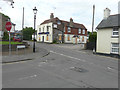
1
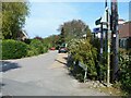
St Margaret's at Cliffe features [3]
The public footpath follows Droveway Gardens and leads to a complex of paths which end at The Droveway or at Kingsdown Road.
St Margaret’s at Cliffe is a coastal village some 3 miles northeast of Dover. The village is the place in Britain that is nearest to the coast of France, 18 miles distant. The area has been settled since Anglo-Saxon times, and the village became a high class resort in the nineteenth century. The area has always been at the front line of cross Channel conflicts.
Image: © Michael Dibb
Taken: 12 Sep 2021
0.02 miles
2
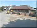
Rosewood, Droveway Gardens
Part of the front garden and that to the west has been ripped up by an excavator. One can only assume that some sort of new surface is to be laid.
Image: © John Baker
Taken: 13 Jul 2014
0.03 miles
3
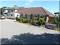
Rosewood, Droveway Gardens
Now that the alterations have been completed to Image, one can see that they were to make a hard-standing for vehicles.
Image: © John Baker
Taken: 2 Jul 2017
0.03 miles
4
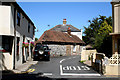
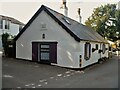
St. Margaret's at Cliffe, Kent: Chapel Lane
Image: © Dr Neil Clifton
Taken: 22 Jul 2010
0.05 miles
5
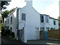
St Margaret's at Cliffe buildings [7]
Cliffe Lodge, Chapel Lane, is a late 18th or early 19th century cottage in rendered brick under a slate roof.
St Margaret’s at Cliffe is a coastal village some 3 miles northeast of Dover. The village is the place in Britain that is nearest to the coast of France, 18 miles distant. The area has been settled since Anglo-Saxon times, and the village became a high class resort in the nineteenth century. The area has always been at the front line of cross Channel conflicts.
Image: © Michael Dibb
Taken: 12 Sep 2021
0.05 miles
6
St Margaret's at Cliffe buildings [6]
Cliffe Cottage, in Cripps' Lane, is an early 19th century house. Constructed of rendered brick under a slate roof. Listed, for group value, grade II, with details at: https://historicengland.org.uk/listing/the-list/list-entry/1347921
St Margaret’s at Cliffe is a coastal village some 3 miles northeast of Dover. The village is the place in Britain that is nearest to the coast of France, 18 miles distant. The area has been settled since Anglo-Saxon times, and the village became a high class resort in the nineteenth century. The area has always been at the front line of cross Channel conflicts.
Image: © Michael Dibb
Taken: 12 Sep 2021
0.06 miles
7
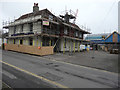
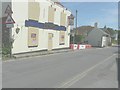
Alterations to Hope Inn, High Street
Planning permission was granted by Dover District Council under application number DOV/15/00120 for the “change of use and conversion of existing building into two dwellings, incorporating a dormer to rear catslide, erection of one detached dwelling, terrace of three dwellings and creation of parking (existing extension and outbuildings to be demolished)”. This shows the Image before any construction work had started.
Image: © John Baker
Taken: 5 Feb 2017
0.06 miles
8
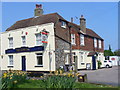
The Hope Inn
One of several inns at St Margaret's-at-Cliffe, an attractive holiday and retirement village on the downs north-east of Dover. This inn shows an interesting mix of brick, flint and tile-hanging.
http://stmargaretspc.co.uk/
Image: © Colin Smith
Taken: 21 Apr 2011
0.06 miles
9
Looking east-southeast along the High Street
Boards have been placed over the windows and door of The Hope Inn while across the entrance to the carpark there are large red and white concrete blocks. Beyond them is Mayfield Cottage at 1 Sea Street, where alterations to this house are talking place; some scaffolding is just visible on the far left of the house. Planning permission has been granted by Dover District Council under application number DOV/11/00590 for the “erection of a rear conservatory and enlargement of rear window (existing conservatory to be demolished)”.
Image: © John Baker
Taken: 13 Jul 2014
0.06 miles
10
The Hope Inn, High Street
The chartered surveyors Porters http://www.porterssurveyors.com/ have placed a board, over the “for sale” board, bearing the words “all enquiries”. Robin Webster’s Image shows large concrete blocks at the entrance to the carpark and that all the windows, bar one, have been boarded over.
Image: © John Baker
Taken: 26 Jun 2016
0.06 miles