IMAGES TAKEN NEAR TO
Reach Road, DOVER, CT15 6AQ
Introduction
This page details the photographs taken nearby to Reach Road, CT15 6AQ by members of the Geograph project.
The Geograph project started in 2005 with the aim of publishing, organising and preserving representative images for every square kilometre of Great Britain, Ireland and the Isle of Man.

There are currently over 7.5m images from over14,400 individuals and you can help contribute to the project by visiting https://www.geograph.org.uk
Image Map
Images are licensed for reuse under creativecommons.org/licenses/by-sa/2.0
Notes
- Clicking on the map will re-center to the selected point.
- The higher the marker number, the further away the image location is from the centre of the postcode.
Image Listing (22 Images Found)
Images are licensed for reuse under creativecommons.org/licenses/by-sa/2.0
Image
Details
Distance
1
Public footpath through corn field
part of the Frontline Britain Trail circular walk
Image: © Arjen Bax
Taken: 12 Aug 2007
0.06 miles
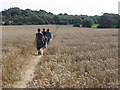
2
![A walk to the South Foreland Lighthouse and return [3]](https://s2.geograph.org.uk/geophotos/07/10/34/7103470_48b22ad6_120x120.jpg)
A walk to the South Foreland Lighthouse and return [3]
The path runs diagonally across this field.
Starting from the church at St Margaret’s at Cliffe, the walk passes through housing then over the flank of Bay Hill. Continuing through an area of scrub laid out with roads (presumably for a housing development that was never built) the lighthouse is reached. The return route is along the cliff tops to the lower part of St Margaret’s at Cliffe before a steep ascent of Bay Hill back to the church.
Image: © Michael Dibb
Taken: 13 Sep 2021
0.09 miles
3
![A walk to the South Foreland Lighthouse and return [4]](https://s0.geograph.org.uk/geophotos/07/10/34/7103476_6fc7126d_120x120.jpg)
A walk to the South Foreland Lighthouse and return [4]
The path now runs along the edge of the wood area towards Lighthouse Road.
Starting from the church at St Margaret’s at Cliffe, the walk passes through housing then over the flank of Bay Hill. Continuing through an area of scrub laid out with roads (presumably for a housing development that was never built) the lighthouse is reached. The return route is along the cliff tops to the lower part of St Margaret’s at Cliffe before a steep ascent of Bay Hill back to the church.
Image: © Michael Dibb
Taken: 13 Sep 2021
0.10 miles
4
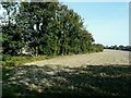
Terminus of dismantled railway, St Margaret's at Cliffe
The line of the hedge marks the end of the military railway referred to in Image
Image: © John Baker
Taken: 25 Sep 2011
0.10 miles
5
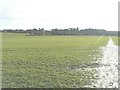
View from St Margaret's at Cliffe over arable land
The line of trees in the middle ground is the Image but seen from the other side. On the right of the frame, a footpath runs in the direction of St Margaret's Bay.
Image: © John Baker
Taken: 21 Dec 2012
0.13 miles
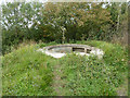
6
Gun emplacement by Lighthouse Road
This is for a small fry gun compared with some of the huge guns that were deployed around here in WWII.
Image: © Robin Webster
Taken: 26 Sep 2015
0.13 miles
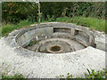
7
Gun emplacement by Lighthouse Road
This is for a small fry gun compared with some of the huge guns that were deployed around here in WWII. For a closer view see Image
Image: © Robin Webster
Taken: 26 Sep 2015
0.13 miles
8
![A walk to the South Foreland Lighthouse and return [5]](https://s0.geograph.org.uk/geophotos/07/10/34/7103480_0a84c836_120x120.jpg)
A walk to the South Foreland Lighthouse and return [5]
The path joins Lighthouse Road.
Starting from the church at St Margaret’s at Cliffe, the walk passes through housing then over the flank of Bay Hill. Continuing through an area of scrub laid out with roads (presumably for a housing development that was never built) the lighthouse is reached. The return route is along the cliff tops to the lower part of St Margaret’s at Cliffe before a steep ascent of Bay Hill back to the church.
Image: © Michael Dibb
Taken: 13 Sep 2021
0.14 miles
9
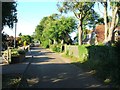
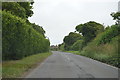
Lighthouse Road, St. Margaret's at Cliffe
Image: © Chris Whippet
Taken: 4 Jul 2015
0.16 miles