IMAGES TAKEN NEAR TO
Waldershare Lane, DOVER, CT15 5GZ
Introduction
This page details the photographs taken nearby to Waldershare Lane, CT15 5GZ by members of the Geograph project.
The Geograph project started in 2005 with the aim of publishing, organising and preserving representative images for every square kilometre of Great Britain, Ireland and the Isle of Man.

There are currently over 7.5m images from over14,400 individuals and you can help contribute to the project by visiting https://www.geograph.org.uk
Image Map
Images are licensed for reuse under creativecommons.org/licenses/by-sa/2.0
Notes
- Clicking on the map will re-center to the selected point.
- The higher the marker number, the further away the image location is from the centre of the postcode.
Image Listing (11 Images Found)
Images are licensed for reuse under creativecommons.org/licenses/by-sa/2.0
Image
Details
Distance
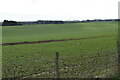
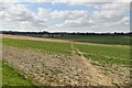
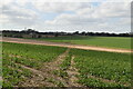
2
Ploughed fields and a belt of trees
The trees are a tongue of woodland projecting from Gifford's Covert off to the left, and appear to act as a shelter belt for Enifer Downs Farm hidden just beyond.
Image: © Robin Webster
Taken: 26 Sep 2015
0.05 miles
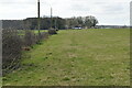
3
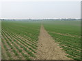
Footpath to Pineham
This path leads from Waldershare Lane near East Langdon, through a large field towards Pineham Bottom Farm.
Image: © David Anstiss
Taken: 27 Mar 2011
0.11 miles
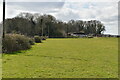
6
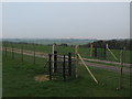
Kissing gates and track to Poison Wood Farm
These two gates are on a footpath crossing through a sheep paddock towards Pineham. The track leads left towards Poison Wood Farm from Waldershare Lane.
Image: © David Anstiss
Taken: 27 Mar 2011
0.19 miles
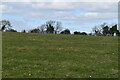
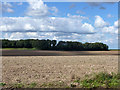
9
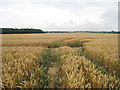
Wheat Field off East Langdon Road
Image: © Oast House Archive
Taken: 24 Jul 2010
0.23 miles