IMAGES TAKEN NEAR TO
Singledge Lane, DOVER, CT15 5AF
Introduction
This page details the photographs taken nearby to Singledge Lane, CT15 5AF by members of the Geograph project.
The Geograph project started in 2005 with the aim of publishing, organising and preserving representative images for every square kilometre of Great Britain, Ireland and the Isle of Man.

There are currently over 7.5m images from over14,400 individuals and you can help contribute to the project by visiting https://www.geograph.org.uk
Image Map
Images are licensed for reuse under creativecommons.org/licenses/by-sa/2.0
Notes
- Clicking on the map will re-center to the selected point.
- The higher the marker number, the further away the image location is from the centre of the postcode.
Image Listing (14 Images Found)
Images are licensed for reuse under creativecommons.org/licenses/by-sa/2.0
Image
Details
Distance
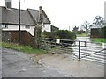
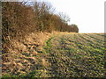
2
Newsole Farm, Singledge Lane
A bridleway, originating from a track near Waldershare House, emerges onto the lane through the farm gates. Newsole Farm dates from 1550. It has a late 17th century façade with Dutch gables (which can be partly seen on the right side of the roof) http://www.shepherdswellwithcoldredpc.kentparishes.gov.uk/UserFiles/file/ColdredChronical_1_.pdf
Image: © John Baker
Taken: 16 Jun 2013
0.04 miles
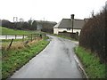
4
View along Singledge Lane in the direction of Whitfield
Image: © Nick Smith
Taken: 15 Dec 2007
0.17 miles
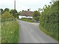
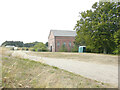
6
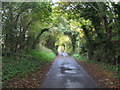
Singledge Lane
This lane leads from Whitfield towards Coldred and Shepherdswell.
Image: © David Anstiss
Taken: 31 Oct 2010
0.18 miles
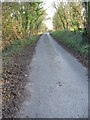
7
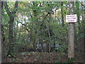
Shooting Cabins in Captain's Wood
As seen from the footpath through the wood leading from Singledge Wood towards Singledge Lane.
Image: © David Anstiss
Taken: 31 Oct 2010
0.21 miles
8
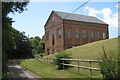
The Winding House, Waldershare
The Winding House was built around 1906 for a private mining company set up to extract coal from seams surrounding Waldershare Park.
Image: © Oast House Archive
Taken: 17 Jul 2010
0.23 miles
9
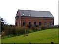
The Winding House
Part of Guildford Colliery
Image: © Bikeboy
Taken: 4 Apr 2018
0.23 miles
10
The Winding House, Singledge Lane
The Winding House is a spectacular restoration of an old Kent coal heritage building, where weddings are held
https://www.akentishceremony.com/venues/the-winding-house/
Image: © John Baker
Taken: 14 Aug 2022
0.23 miles