IMAGES TAKEN NEAR TO
Vicarage Lane, DOVER, CT15 4LA
Introduction
This page details the photographs taken nearby to Vicarage Lane, CT15 4LA by members of the Geograph project.
The Geograph project started in 2005 with the aim of publishing, organising and preserving representative images for every square kilometre of Great Britain, Ireland and the Isle of Man.

There are currently over 7.5m images from over14,400 individuals and you can help contribute to the project by visiting https://www.geograph.org.uk
Image Map
Images are licensed for reuse under creativecommons.org/licenses/by-sa/2.0
Notes
- Clicking on the map will re-center to the selected point.
- The higher the marker number, the further away the image location is from the centre of the postcode.
Image Listing (66 Images Found)
Images are licensed for reuse under creativecommons.org/licenses/by-sa/2.0
Image
Details
Distance
1
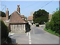
Junction of Church Street and Vicarage Lane
Image: © Nick Smith
Taken: 14 Apr 2007
0.03 miles
2
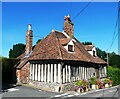
Toll Cottage, Nonington
A Grade II listed building, 15th century or earlier, said to have an early 13th century origin.
Image: © pam fray
Taken: 23 Aug 2023
0.04 miles
3
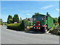
AEC Matador, Nonington
A 4X4 design for the army, built 1952. Re-registered and probably partially rebodied as civilian WFF 733 in 1995.
Image: © Robin Webster
Taken: 4 Jun 2015
0.04 miles
5
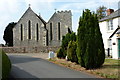
The church of St. Mary the Virgin, Nonington
The corner of Church House can be seen to the right.
Image: © pam fray
Taken: 21 Sep 2009
0.05 miles
7
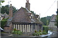
Toll Cottage
Grade II listed. http://www.britishlistedbuildings.co.uk/en-178029-toll-cottage-nonington-kent
Image: © N Chadwick
Taken: 2 Jul 2016
0.06 miles
8
Looking northwest along Vicarage Lane
The half-timbered house on the left is Toll Cottage, which is a grade II listed building dating from the 15th century or earlier
http://www.britishlistedbuildings.co.uk/en-178029-toll-cottage-nonington-kent
and, in the distance, St Mary’s church, which is a grade I listed building that dates from the late 13th century but was restored in 1867 and 1887 http://www.britishlistedbuildings.co.uk/en-178014-church-of-st-mary-nonington-kent
Image: © John Baker
Taken: 19 Apr 2014
0.06 miles
9
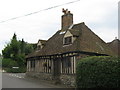
Toll Cottage
On the junction of Old Court Hill (which becomes Vicarage Lane) on the left, and Church Street (behind the cottage).
Image: © David Anstiss
Taken: 5 Sep 2010
0.06 miles
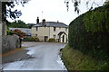
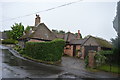
10
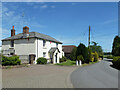
Church House, Nonington
The church is off to the left.
Image: © Robin Webster
Taken: 4 Jun 2015
0.06 miles