IMAGES TAKEN NEAR TO
St. Marys Close, DOVER, CT15 4JX
Introduction
This page details the photographs taken nearby to St. Marys Close, CT15 4JX by members of the Geograph project.
The Geograph project started in 2005 with the aim of publishing, organising and preserving representative images for every square kilometre of Great Britain, Ireland and the Isle of Man.

There are currently over 7.5m images from over14,400 individuals and you can help contribute to the project by visiting https://www.geograph.org.uk
Image Map
Images are licensed for reuse under creativecommons.org/licenses/by-sa/2.0
Notes
- Clicking on the map will re-center to the selected point.
- The higher the marker number, the further away the image location is from the centre of the postcode.
Image Listing (77 Images Found)
Images are licensed for reuse under creativecommons.org/licenses/by-sa/2.0
Image
Details
Distance

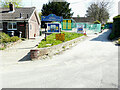
5
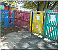
Nonington Church of England Primary School, Church Street
Dover District Council has not raised any objection to planning application number DOV/20/00862 “to remove the timber-framed mobile classroom building and timber framed lodge behind and construct a traditionally constructed brick / block classroom extension. This is a single storey extension with a flat roof, providing classrooms, toilets and storage, connecting into the corridor in the existing school building to aid internal circulation”
The timber-framed mobile classroom building lies just beyond the fence.
Image: © John Baker
Taken: 13 Sep 2020
0.10 miles
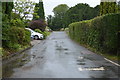
7
Nonington Church Of England Primary School, Church Street
This view of Image shows the school, before any ongoing work had started to build a traditionally constructed brick-block classroom extension.
Image: © John Baker
Taken: 24 Apr 2022
0.12 miles
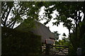
9
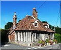
Toll Cottage, Nonington
A Grade II listed building, 15th century or earlier, said to have an early 13th century origin.
Image: © pam fray
Taken: 23 Aug 2023
0.13 miles
10
Flint wall, Church Street
The Image has been repaired, if rather badly.
Image: © John Baker
Taken: 24 Apr 2022
0.13 miles