IMAGES TAKEN NEAR TO
Sandwich Road, DOVER, CT15 4FA
Introduction
This page details the photographs taken nearby to Sandwich Road, CT15 4FA by members of the Geograph project.
The Geograph project started in 2005 with the aim of publishing, organising and preserving representative images for every square kilometre of Great Britain, Ireland and the Isle of Man.

There are currently over 7.5m images from over14,400 individuals and you can help contribute to the project by visiting https://www.geograph.org.uk
Image Map
Images are licensed for reuse under creativecommons.org/licenses/by-sa/2.0
Notes
- Clicking on the map will re-center to the selected point.
- The higher the marker number, the further away the image location is from the centre of the postcode.
Image Listing (72 Images Found)
Images are licensed for reuse under creativecommons.org/licenses/by-sa/2.0
Image
Details
Distance
1
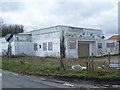
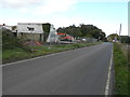
Derelict Snowdown Working Men's Club
Snowdown was the deepest of the four main pits in the Kent Coalfield, - see http://en.wikipedia.org/wiki/Kent_Coalfield , reaching a depth of 3,083 feet. Work commenced in 1908, and coal was first brought to the surface on November 19th 1912. The first shaft sunk hit water at 260 feet and 22 men were drowned. The colliery was served by the Faversham to Dover railway, and a halt called Snowdown & Nonington was provided. The new town of Aylesham was built just to the north of the colliery to provide homes for the many migrant workers from Wales and the north-east of England. In 1945 the workforce was 1,876, with 1,523 being employed sub-surface and 353 above. The colliery closed in 1986 and the shafts were capped in 1988. Just on the other side of the station from the former colliery was Snowdown Working Men's Club. Like so much else in this immediate area it has seen better days.
Update:- by 2020 it had gone and been replaced by new houses but the old colliery across the road was still there - see www.geograph.org.uk/photo/3413529
Image: © Marathon
Taken: 12 Apr 2013
0.00 miles
2
Demolition of Snowdown Working Men?s Club
This is Image as it appeared almost two years ago.
Image: © John Baker
Taken: 15 Sep 2015
0.00 miles

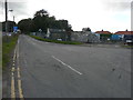
4
Snowdown Working Men's Club
Situated on the corner of an unclassified road, to its left, and Aylesham Road, it is being reallocated to Burgess Road, Aylesham.
Image: © John Baker
Taken: 30 Oct 2013
0.01 miles
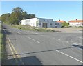
5
Ongoing construction of Weston Mews
Planning permission has been granted by Dover District Council under application number DOV/13/01037 for the “demolition of existing clubhouse and dwelling and the erection of 8 dwellings (four pairs of semi-detached dwellings), construction of vehicular access, associated parking and landscaping”. The clubhouse could be seen, in this view of October 2013, when Image In the distance, Network Rail had erected traffic lights to control traffic using the bridge over the railway.
This was Image after completion.
Image: © John Baker
Taken: 3 Jul 2016
0.01 miles
6
Demolition of Snowdown Working Men?s Club
Image: © John Baker
Taken: 15 Sep 2015
0.01 miles
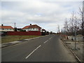
7
Recently cleared demolition site
Compared with the view showing the Image, almost all traces of the demolition equipment have been removed, leaving a clearer view of houses in South Avenue.
Image: © John Baker
Taken: 11 Oct 2015
0.01 miles
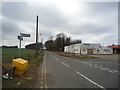
10
Snowdown Working Men's Club
Not working; like the mine across the road.
Image: © Des Blenkinsopp
Taken: 27 Aug 2011
0.01 miles