IMAGES TAKEN NEAR TO
Palm Tree Close, DOVER, CT15 4BU
Introduction
This page details the photographs taken nearby to Palm Tree Close, CT15 4BU by members of the Geograph project.
The Geograph project started in 2005 with the aim of publishing, organising and preserving representative images for every square kilometre of Great Britain, Ireland and the Isle of Man.

There are currently over 7.5m images from over14,400 individuals and you can help contribute to the project by visiting https://www.geograph.org.uk
Image Map
Images are licensed for reuse under creativecommons.org/licenses/by-sa/2.0
Notes
- Clicking on the map will re-center to the selected point.
- The higher the marker number, the further away the image location is from the centre of the postcode.
Image Listing (30 Images Found)
Images are licensed for reuse under creativecommons.org/licenses/by-sa/2.0
Image
Details
Distance
1
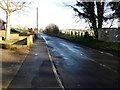
Looking north-northeast along Monkton Court Lane
There had been a severe overnight frost, which had led to black ice on this (and other) roads. It was still very slippery underfoot.
Image: © John Baker
Taken: 22 Feb 2015
0.05 miles
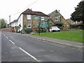
2
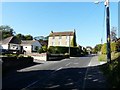
Upper Eythorne
This road is called The Street.
Image: © John Baker
Taken: 12 Oct 2009
0.06 miles
3
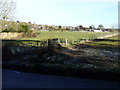
Field beside Monkton Court Lane
Seen from Kennel Hill, there had been a severe overnight frost, which had led to black ice on this (and other) roads. It was still very slippery underfoot.
Image: © John Baker
Taken: 22 Feb 2015
0.07 miles
4
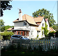
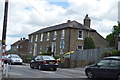
1, Kennel Hill
Planning permission has been granted by Dover District Council under application number DOV/20/00491 for the “erection of two storey side and rear extensions with side porch (existing conservatory and rear extension to be demolished)”.
Image: © John Baker
Taken: 22 Jul 2020
0.09 miles
7
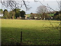
Paddock to the S of The Street, Eythorne
Taken from just off the footpath that runs between Eythorne and Waldershare.
Image: © Nick Smith
Taken: 5 Jan 2008
0.17 miles
8
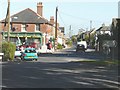
Upper Eythorne Village Stores and Post Office
The road to the right of the village stores is called Sandwich Road.
Image: © John Baker
Taken: 12 Oct 2009
0.18 miles
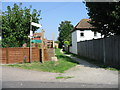
9
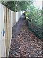
Footpath into Eythorne from Waldershare
The section of footpath from The Street in Eythorne is rather dull, a narrow, slippery mud path with 2 meter high fence panels either side, once clear of the houses it opens out into parkland.
Image: © Nick Smith
Taken: 5 Jan 2008
0.18 miles