IMAGES TAKEN NEAR TO
Cornfield Row, DEAL, CT14 9YE
Introduction
This page details the photographs taken nearby to Cornfield Row, CT14 9YE by members of the Geograph project.
The Geograph project started in 2005 with the aim of publishing, organising and preserving representative images for every square kilometre of Great Britain, Ireland and the Isle of Man.

There are currently over 7.5m images from over14,400 individuals and you can help contribute to the project by visiting https://www.geograph.org.uk
Image Map
Images are licensed for reuse under creativecommons.org/licenses/by-sa/2.0
Notes
- Clicking on the map will re-center to the selected point.
- The higher the marker number, the further away the image location is from the centre of the postcode.
Image Listing (28 Images Found)
Images are licensed for reuse under creativecommons.org/licenses/by-sa/2.0
Image
Details
Distance
1
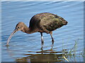
Glossy Ibis feeding in small pool
A surprising visitor to a small pool very near a new housing estate. This Glossy Ibis has been there for about a week.
Image: © Nick Smith
Taken: 30 Sep 2022
0.09 miles
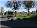
3
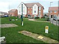
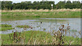
Public open space, off Swift Crescent
With gas supply infrastructure in the foreground.
Image: © Christine Johnstone
Taken: 17 Feb 2022
0.10 miles
4
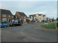
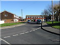
At the junction of Dola Avenue and Church Lane
Where different housing developments meet, in Deal's western suburbs.
Image: © Christine Johnstone
Taken: 17 Feb 2022
0.13 miles
6
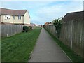
Between Swift Crescent and Church Meadows
This footpath is shown on the large scale OS map surveyed in 1871-2 and has survived the transition from farmland to suburbia.
Image: © Christine Johnstone
Taken: 17 Feb 2022
0.14 miles
7
Church Lane from junction with Orchard Avenue
Image: © Nick Smith
Taken: 17 Feb 2008
0.16 miles
8
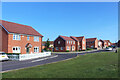
New Housing, Cornfield Road
These houses on Cornfield Road are on the edge of Deal's built up area and they do, for the time being at least, overlook farmland.
Image: © Des Blenkinsopp
Taken: 12 Jun 2021
0.16 miles
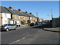
9
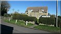
Old housing, Southwall Road, Deal
Shown on the large scale OS map surveyed in 1871-2. Then, surrounded by drained fields. Now, close to a new housing estate and an industrial estate.
Image: © Christine Johnstone
Taken: 17 Feb 2022
0.17 miles