IMAGES TAKEN NEAR TO
William Pitt Avenue, DEAL, CT14 9QF
Introduction
This page details the photographs taken nearby to William Pitt Avenue, CT14 9QF by members of the Geograph project.
The Geograph project started in 2005 with the aim of publishing, organising and preserving representative images for every square kilometre of Great Britain, Ireland and the Isle of Man.

There are currently over 7.5m images from over14,400 individuals and you can help contribute to the project by visiting https://www.geograph.org.uk
Image Map
Images are licensed for reuse under creativecommons.org/licenses/by-sa/2.0
Notes
- Clicking on the map will re-center to the selected point.
- The higher the marker number, the further away the image location is from the centre of the postcode.
Image Listing (27 Images Found)
Images are licensed for reuse under creativecommons.org/licenses/by-sa/2.0
Image
Details
Distance
1
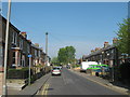
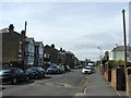
Southwall Road, Deal
This road leads from Middle Deal Road towards Church Lane.
It is also part of a cycle route towards Fowlmead Country Park.
Image: © David Anstiss
Taken: 17 Apr 2011
0.09 miles
2
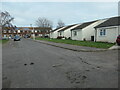
Terraced bungalows, Dola Avenue, Deal
This road and this suburb were built since 1950.
Image: © Christine Johnstone
Taken: 17 Feb 2022
0.09 miles
3
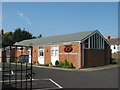
Deal Christian Fellowship Centre
At the end of Sutherland Road.
Image: © David Anstiss
Taken: 17 Apr 2011
0.10 miles
5
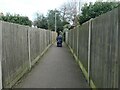
Path from Dola Avenue to Belvedere Gardens, Deal
A public footpath running between a garden wall and the back of a row of garages.
Image: © Christine Johnstone
Taken: 17 Feb 2022
0.11 miles
7
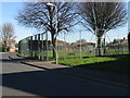
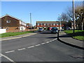
At the junction of Dola Avenue and Church Lane
Where different housing developments meet, in Deal's western suburbs.
Image: © Christine Johnstone
Taken: 17 Feb 2022
0.14 miles
8
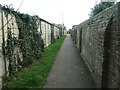
Public footpath from The Grove to Sutherland Road
This public footpath in Deal is shown on the large scale OS map surveyed in 1871-2, when it was called Cross Walk.
Image: © Christine Johnstone
Taken: 17 Feb 2022
0.15 miles
10
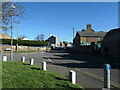
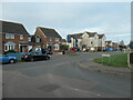
Middle Deal Road, Deal
At the junction with Southwall Road
Image: © Christine Johnstone
Taken: 17 Feb 2022
0.16 miles