IMAGES TAKEN NEAR TO
Mongeham Road, DEAL, CT14 9LR
Introduction
This page details the photographs taken nearby to Mongeham Road, CT14 9LR by members of the Geograph project.
The Geograph project started in 2005 with the aim of publishing, organising and preserving representative images for every square kilometre of Great Britain, Ireland and the Isle of Man.

There are currently over 7.5m images from over14,400 individuals and you can help contribute to the project by visiting https://www.geograph.org.uk
Image Map
Images are licensed for reuse under creativecommons.org/licenses/by-sa/2.0
Notes
- Clicking on the map will re-center to the selected point.
- The higher the marker number, the further away the image location is from the centre of the postcode.
Image Listing (62 Images Found)
Images are licensed for reuse under creativecommons.org/licenses/by-sa/2.0
Image
Details
Distance
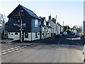
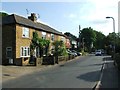
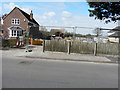
2

Mongeham Road
Planning permission has been approved by Dover District Council under application number DOV/18/00764 for the “erection of 35 houses, formation of new access road, associated landscaping including demolition of Stalco Engineering Buildings, former squash courts and 126, Mongeham Road. Off-site highway works to include a pedestrian build-out”.
The development will also include this Image, which, here, is partly hidden by scaffolding and plastic sheeting.
Image: © John Baker
Taken: 23 Oct 2022
0.04 miles
3
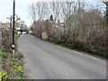
Derelict building, Mongeham Farm, Mongeham Road
This was one of the two malthouses in operation in the village through the eighteenth and nineteenth centuries. In the nineteenth century [this] one was operated by the Bray family and the other by the Harrisons http://www.greatmongehamsociety.co.uk/great-mongeham-history/east-kent-history/139-great-mongeham-malthouses.html
The second malthouse [this one] in the village belonged to Samuel Shepherd who lived in the Manor House in the early eighteenth century. He might very well have built the large malthouse next door. He was later to move to Faversham where he was to found the brewery that was to become Shepherd Neame.
In 1775 Admiral Bray bought the Manor House, together with the malthouse. The house and malthouse were to remain in the family until 1892. Although malting provided a substantial income, the Brays were principally farmers. They employed a maltster, Joseph Hewitt, for the day to day operations of the malthouse. In a declaration in 1864 by Margaret Bray, daughter of John Bray, she writes that Joseph had been in the service of the family for more than sixty years and maltman for 54 years. He lived in the house from which his wife ran a grocer’s shop. It was situated next door to the Three Horseshoes.
By 1883 the malthouse had been leased to Thompson’s brewers of Walmer. In the First World War it provided stabling for horses bound for the front http://www.greatmongehamsociety.co.uk/great-mongeham-history/east-kent-history/139-great-mongeham-malthouses.html?start=4
Image: © John Baker
Taken: 20 Mar 2016
0.05 miles
4
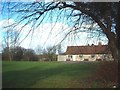
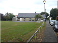
Mongeham Village Hall
In Great Mongeham, near the junction of Northbourne Road and Mongeham Road.
Image: © Rosie Burnham
Taken: 16 Feb 2006
0.05 miles
5
Mongeham Road
Planning permission has been approved by Dover District Council under application number DOV/18/00764 for the “erection of 35 houses, formation of new access road, associated landscaping including demolition of Stalco Engineering Buildings, former squash courts and 126, Mongeham Road. Off-site highway works to include a pedestrian build-out”.
The development will also include this Image
Image: © John Baker
Taken: 23 Oct 2022
0.05 miles
6
Mongeham Village Hall, 170, Mongeham Road
Planning permission was granted by Dover District Council under application number DOV/16/00566 for the “re-roofing of hall”. The planning application included the words “proposed re-roofing of hall including replacement of felted flat roofs with slate tiles pitched roofs”, which explains why the hall’s appearance is different from Rosie Burnham’s Image
Image: © John Baker
Taken: 4 Sep 2016
0.05 miles
8
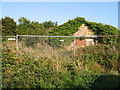
Derelict buildings off Mongeham Road
Soon to be lost completely under a blanket of ivy.
Image: © Nick Smith
Taken: 19 Sep 2008
0.08 miles
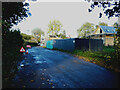
10
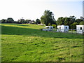
Building site, Mongeham Road
Planning permission has been granted by Dover District Council under application number DOV/14/01146 for the “erection of a detached dwelling with associated parking”. The location was given as land adjacent to 162, Mongeham Road.
This was Image during its construction.
Image: © John Baker
Taken: 20 Mar 2016
0.08 miles