IMAGES TAKEN NEAR TO
Coldblow, DEAL, CT14 9JH
Introduction
This page details the photographs taken nearby to Coldblow, CT14 9JH by members of the Geograph project.
The Geograph project started in 2005 with the aim of publishing, organising and preserving representative images for every square kilometre of Great Britain, Ireland and the Isle of Man.

There are currently over 7.5m images from over14,400 individuals and you can help contribute to the project by visiting https://www.geograph.org.uk
Image Map
Images are licensed for reuse under creativecommons.org/licenses/by-sa/2.0
Notes
- Clicking on the map will re-center to the selected point.
- The higher the marker number, the further away the image location is from the centre of the postcode.
Image Listing (33 Images Found)
Images are licensed for reuse under creativecommons.org/licenses/by-sa/2.0
Image
Details
Distance
8
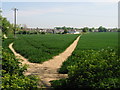
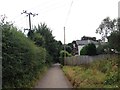
Footpath to Walmer
These paths are a bit confusing, the map shows two footpaths from this corner, one running roughly NE to Walmer the other roughly SE towards Kings Farm on the A258. The two tracks shown here seem to run in the same direction, the left hand one appears to curve around and join the other one in the distance.
Image: © Nick Smith
Taken: 11 May 2008
0.04 miles
9
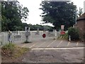
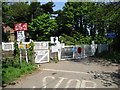
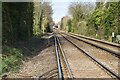
Level Crossing, Coldblow Road, near Walmer
Image: © Chris Whippet
Taken: 3 Aug 2016
0.05 miles
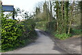
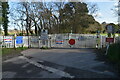
10
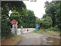
Level Crossing, Coldblow Road, near Walmer
Image: © Chris Whippet
Taken: 3 Aug 2016
0.05 miles