IMAGES TAKEN NEAR TO
Hamilton Road, DEAL, CT14 9BP
Introduction
This page details the photographs taken nearby to Hamilton Road, CT14 9BP by members of the Geograph project.
The Geograph project started in 2005 with the aim of publishing, organising and preserving representative images for every square kilometre of Great Britain, Ireland and the Isle of Man.

There are currently over 7.5m images from over14,400 individuals and you can help contribute to the project by visiting https://www.geograph.org.uk
Image Map
Images are licensed for reuse under creativecommons.org/licenses/by-sa/2.0
Notes
- Clicking on the map will re-center to the selected point.
- The higher the marker number, the further away the image location is from the centre of the postcode.
Image Listing (30 Images Found)
Images are licensed for reuse under creativecommons.org/licenses/by-sa/2.0
Image
Details
Distance
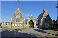
2
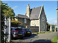
Lodge, Deal Cemetery
By the entrance on Hamilton Road.
Image: © Robin Webster
Taken: 14 Oct 2017
0.06 miles
3
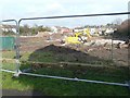
Building site, Mill Road
Seen from a cul-de-sac leading to a cemetery. Planning permission, with conditions, has been granted by Dover District Council under application number DOV/12/00311 for a “residential development comprising of 38 dwellings and 6 flats, construction of vehicular access and associated car parking and landscaping (existing school buildings to be demolished)”. The school referred to was the South Deal County Primary. The new development has been named Stanhope Place. On the left are the backs of houses in Mill Road, while beyond the JCB are the backs of houses in Hamilton Road.
See also Image from another angle.
Image: © John Baker
Taken: 27 Jan 2014
0.07 miles
4

Building site, Mill Road
As can be seen from the notice-board the new development has been named Stanhope Place. Planning permission, with conditions, has been granted by Dover District Council under application number DOV/12/00311 for a “residential development comprising of 38 dwellings and 6 flats, construction of vehicular access and associated car parking and landscaping (existing school buildings to be demolished)”. The school referred to was the South Deal County Primary.
See also Image from another angle.
Image: © John Baker
Taken: 27 Jan 2014
0.07 miles
5

Stanhope Place, Mill Road
In January 2014, it was just a Image Now work is well underway and some of the houses are nearing completion.
Image: © John Baker
Taken: 2 Jul 2014
0.07 miles
7
Chapels, Deal Cemetery
As built, a Non-conformist chapel was on the left, a Church of England one on the right. Modern maps now only show that on the left as a place of worship.
Image: © Robin Webster
Taken: 14 Oct 2017
0.08 miles
8
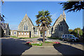
Chapels, Deal Cemetery
As built, a Non-conformist chapel was on the left, a Church of England one on the right. Modern maps now only show that on the left as a place of worship.
Image: © Robin Webster
Taken: 14 Oct 2017
0.08 miles
9
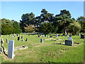
In Deal Cemetery
It is possible to use the cemetery as a through walking route.
Image: © Robin Webster
Taken: 14 Oct 2017
0.08 miles
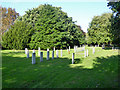
10
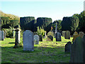
In Deal Cemetery
Older graves not far from the main entrance. The cemetery opened in 1856.
Image: © Robin Webster
Taken: 14 Oct 2017
0.09 miles