IMAGES TAKEN NEAR TO
Church Lane, DEAL, CT14 8JH
Introduction
This page details the photographs taken nearby to Church Lane, CT14 8JH by members of the Geograph project.
The Geograph project started in 2005 with the aim of publishing, organising and preserving representative images for every square kilometre of Great Britain, Ireland and the Isle of Man.

There are currently over 7.5m images from over14,400 individuals and you can help contribute to the project by visiting https://www.geograph.org.uk
Image Map
Images are licensed for reuse under creativecommons.org/licenses/by-sa/2.0
Notes
- Clicking on the map will re-center to the selected point.
- The higher the marker number, the further away the image location is from the centre of the postcode.
Image Listing (71 Images Found)
Images are licensed for reuse under creativecommons.org/licenses/by-sa/2.0
Image
Details
Distance
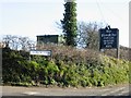
3
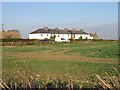
Houses on Church Lane, Ripple
Taken from Chapel Lane
Image: © Nick Smith
Taken: 16 Dec 2007
0.02 miles
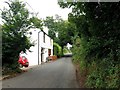
4
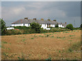
Terrace of Houses on Church Lane
Looking across from Chapel Lane.
Image: © Oast House Archive
Taken: 24 Jul 2010
0.02 miles
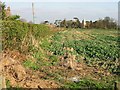

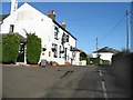
7
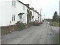
Portland Terrace, Church Lane, Ripple
A terrace of ten dwellings, with the spire of St Mary the Virgin in Image in the distance.
Image: © John Baker
Taken: 30 Dec 2012
0.03 miles