IMAGES TAKEN NEAR TO
Maxwell Place, DEAL, CT14 7XU
Introduction
This page details the photographs taken nearby to Maxwell Place, CT14 7XU by members of the Geograph project.
The Geograph project started in 2005 with the aim of publishing, organising and preserving representative images for every square kilometre of Great Britain, Ireland and the Isle of Man.

There are currently over 7.5m images from over14,400 individuals and you can help contribute to the project by visiting https://www.geograph.org.uk
Image Map
Images are licensed for reuse under creativecommons.org/licenses/by-sa/2.0
Notes
- Clicking on the map will re-center to the selected point.
- The higher the marker number, the further away the image location is from the centre of the postcode.
Image Listing (237 Images Found)
Images are licensed for reuse under creativecommons.org/licenses/by-sa/2.0
Image
Details
Distance
1

Clock tower in Deal
This clock is on what appears to be a naval building.
Image: © Philip Halling
Taken: 18 Jul 2009
0.09 miles
2
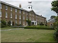
The former Deal Barracks
On 22nd September 1989 the Provisional IRA exploded a time bomb at the Royal Marines School of Music housed here. Eleven musicians were killed. The full story can be seen here - https://en.wikipedia.org/wiki/Deal_barracks_bombing
A memorial bandstand was constructed at Walmer Green to the memory of those who "only ever wanted to play music". It has the names of the eleven who lost their lives around the base - see http://www.geograph.org.uk/photo/5070008
The surviving barracks at Deal were converted into flats when the base was decommissioned in 1996, and the School of Music is once again based in Portsmouth from where it had moved to Deal in 1950.
Image: © Marathon
Taken: 7 Aug 2016
0.10 miles
3
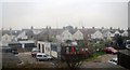
Looking north-northwest along The Strand
In the distance, on the left, the clock tower of Admiralty Mews is encased in scaffolding. Admiralty Mews was the site of the former naval hospital that was built in 1812, after the hospital was struck by lightning. It is now residential housing.
Image: © John Baker
Taken: 13 Dec 2014
0.11 miles
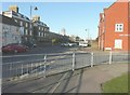
4
A white house on the corner
North Barrack Road, Walmer.
Image: © Anthony Vosper
Taken: 21 Sep 2020
0.11 miles
5
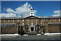
Admiralty Mews, Deal
This building is the former Royal Marines School of Music in Deal.
Image: © Philip Halling
Taken: 18 Jul 2009
0.11 miles
8
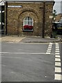
Former Marine Barracks Postroom
The former barracks postroom on the corner of North Barrack Road and Campbell Road. On the angle is military boundary marker. See https://www.geograph.org.uk/photo/6918493 for a closer view. Photo by Sheila Harris, with permission.
Image: © Sheila Harris
Taken: 30 Jul 2021
0.13 miles
9
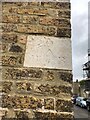
Military Boundary Marker on the Corner of North Barrack Road and Campbell Road
On the angle of the former barracks postroom is military boundary marker. See https://www.geograph.org.uk/photo/6918490 for a wider view. Photo by Sheila Harris, with permission.
Milestone Society National ID: KE_BBWALM01em
Image: © Sheila Harris
Taken: 25 Jun 2021
0.13 miles
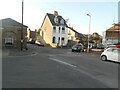
10
Ashley Scott, 60, The Strand
Planning permission has been granted by Dover District Council under application number DOV/17/01334 for “part change of use to residential”.
Image: © John Baker
Taken: 5 Mar 2018
0.13 miles