IMAGES TAKEN NEAR TO
Archery Square, DEAL, CT14 7JA
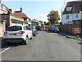
Introduction
This page details the photographs taken nearby to Archery Square, CT14 7JA by members of the Geograph project.
The Geograph project started in 2005 with the aim of publishing, organising and preserving representative images for every square kilometre of Great Britain, Ireland and the Isle of Man.

There are currently over 7.5m images from over14,400 individuals and you can help contribute to the project by visiting https://www.geograph.org.uk
Image Map
Images are licensed for reuse under creativecommons.org/licenses/by-sa/2.0
Notes
- Clicking on the map will re-center to the selected point.
- The higher the marker number, the further away the image location is from the centre of the postcode.
Image Listing (68 Images Found)
Images are licensed for reuse under creativecommons.org/licenses/by-sa/2.0
Image
Details
Distance
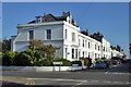
1
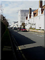
Looking northwest along Archery Square
Most of two houses have been hidden by an erection of scaffolding and plastic sheeting. The nearer house is number 34. Planning permission has been granted by Dover District Council under application number DOV/15/00696 to “replace existing orangery roof light with roof lantern, installation of French doors to rear, relocation of existing soil vent pipe and associated internal and external alterations” and DOV/15/00697 to "remove existing orangery roof light and replace with roof lantern, installation of French doors to rear". The further house is number 18 and it is to be supposed that the reason for the scaffolding is that the house is undergoing a major refurbishment
Image: © John Baker
Taken: 20 Mar 2016
0.06 miles
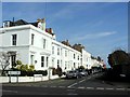
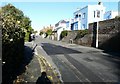
2
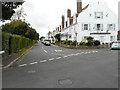
Looking northwest along Archery Square
On a previous visit Image, showed two houses mostly hidden by an erection of scaffolding and plastic sheeting. This view shows the road as it appears today.
Image: © John Baker
Taken: 4 Sep 2016
0.06 miles
3
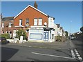
Former corner shop
The sign over the entrance reads "Walmer Stores" but look inside and one only sees bric-à-brac. The shop is situated on the corner of Herschell Road East and Dover Road.
Image: © John Baker
Taken: 10 Nov 2013
0.07 miles
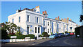
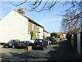
5
Houses, Archery Square, Walmer
Some houses are listed towards the far end, but not at this end.
Image: © Robin Webster
Taken: 14 Oct 2017
0.07 miles
8
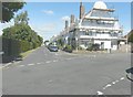
12 Liverpool Road
Scaffolding has been erected on the frontage and along the side (in Archery Square) of this house with its Dutch gable.
Image: © John Baker
Taken: 2 Jul 2014
0.08 miles
9
Liverpool Road
The road was closed at its junction with Archery Square, as Southern Water was repairing the sewage system.
Image: © John Baker
Taken: 27 May 2020
0.08 miles
10
Houses along Liverpool Road
Seen from near to the junction with Archery Square (there are two roads with this name but only one is marked on the map).
Image: © John Baker
Taken: 10 Nov 2013
0.09 miles