IMAGES TAKEN NEAR TO
Trafalgar Drive, DEAL, CT14 7FJ
Introduction
This page details the photographs taken nearby to Trafalgar Drive, CT14 7FJ by members of the Geograph project.
The Geograph project started in 2005 with the aim of publishing, organising and preserving representative images for every square kilometre of Great Britain, Ireland and the Isle of Man.

There are currently over 7.5m images from over14,400 individuals and you can help contribute to the project by visiting https://www.geograph.org.uk
Image Map
Images are licensed for reuse under creativecommons.org/licenses/by-sa/2.0
Notes
- Clicking on the map will re-center to the selected point.
- The higher the marker number, the further away the image location is from the centre of the postcode.
Image Listing (180 Images Found)
Images are licensed for reuse under creativecommons.org/licenses/by-sa/2.0
Image
Details
Distance
1
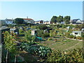
Campbell Road allotments
Ready for harvest. A group of well maintained allotment gardens.
Situated in the heart of town.
Image: © Anthony Vosper
Taken: 22 Sep 2020
0.06 miles
2
67c & d, York Road
This image of Image shows the semi-detached houses under construction.
Image: © John Baker
Taken: 5 Mar 2018
0.07 miles
3
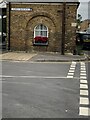
Former Marine Barracks Postroom
The former barracks postroom on the corner of North Barrack Road and Campbell Road. On the angle is military boundary marker. See https://www.geograph.org.uk/photo/6918493 for a closer view. Photo by Sheila Harris, with permission.
Image: © Sheila Harris
Taken: 30 Jul 2021
0.07 miles
4
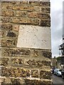
Military Boundary Marker on the Corner of North Barrack Road and Campbell Road
On the angle of the former barracks postroom is military boundary marker. See https://www.geograph.org.uk/photo/6918490 for a wider view. Photo by Sheila Harris, with permission.
Milestone Society National ID: KE_BBWALM01em
Image: © Sheila Harris
Taken: 25 Jun 2021
0.07 miles
5
Looking northwest along York Road
The building, under construction was granted planning permission by Dover District Council under application number DOV/99/00378 for the “erection of two, 2-storey semi-detached dwellings”. The location given was “on a site adjacent to 67, York Road”; this is the house outside of which a grey car is parked.
Planning permission was also granted by Dover District Council under application number DOV/10/00545 for a “variation of condition 4 of planning permission DOV/05/1375 to allow use of upvc fenestration and removal of condition 6 of planning permission DOV/051375 to allow the installation of vents” for the house at the far end of the road, whose postal address is 1, North Barrack Road; it was the former location of Mark 1 Music, which is now situated at 12-16 Victoria Road.
Image: © John Baker
Taken: 27 Jan 2014
0.07 miles
6
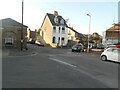
A white house on the corner
North Barrack Road, Walmer.
Image: © Anthony Vosper
Taken: 21 Sep 2020
0.07 miles
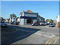
7
Premises along North Barrack Road
On the left, is number 1, whose side wall can be seen in Image and which is undergoing redevelopment.
Image: © John Baker
Taken: 27 Jan 2014
0.07 miles
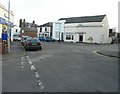
8
Autobase, North Barrack Road
An Art Deco style garage. Now selling up market bicycles.
Image: © Anthony Vosper
Taken: 21 Sep 2020
0.08 miles
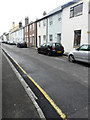
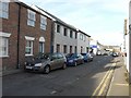
9
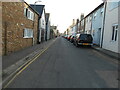
York Road
A quiet back street running parallel to the main seafront road.
The small building on the left is a former garage with sliding doors. This has been converted into two small holiday flats.
Image: © Anthony Vosper
Taken: 21 Sep 2020
0.08 miles
10
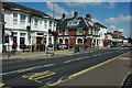
Seafront at Deal
Houses and shops overlooking the seafront in Deal.
Image: © Philip Halling
Taken: 18 Jul 2009
0.09 miles