IMAGES TAKEN NEAR TO
Wollaston Road, DEAL, CT14 7EB
Introduction
This page details the photographs taken nearby to Wollaston Road, CT14 7EB by members of the Geograph project.
The Geograph project started in 2005 with the aim of publishing, organising and preserving representative images for every square kilometre of Great Britain, Ireland and the Isle of Man.

There are currently over 7.5m images from over14,400 individuals and you can help contribute to the project by visiting https://www.geograph.org.uk
Image Map (Loading...)


Getting Data...Please wait
Leaflet Map data © OpenStreetMap
Images are licensed for reuse under creativecommons.org/licenses/by-sa/2.0
Notes
- Clicking on the map will re-center to the selected point.
- The higher the marker number, the further away the image location is from the centre of the postcode.
Image Listing (208 Images Found)
Images are licensed for reuse under creativecommons.org/licenses/by-sa/2.0
Image
Details
Distance
1

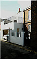
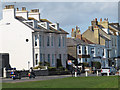
23, The Strand, Walmer
Planning permission has been granted by Dover District Council under application number DOV/19/00736 for the “proposed use as a holiday let, erection of single storey rear extension, alterations to doors and windows and external changes to create carport (existing garage/utility room to be demolished)” and under application number DOV/19/00736/A for a “non-material amendment to DOV/19/00736 for the insertion of an additional window”.
This was Image when the alterations had been completed.
This is the view from Wollaston Road.
Image: © John Baker
Taken: 27 May 2020
0.01 miles
2
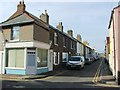
23, The Strand
This was Image when alterations to the house were taking place.
This is the view from Wollaston Road.
Image: © John Baker
Taken: 15 Mar 2021
0.01 miles
4
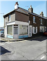
39, York Road
It appears that this part of the house was once a shop.
Image: © John Baker
Taken: 27 May 2020
0.01 miles
5
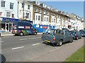
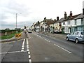
The Strand
The blue hoarding hides the Deal branch of Le Vaillant Owen, at number 29, which is a consultancy offering services in sustainable development, community regeneration, housing and planning, environment, architecture and health and corporate social responsibility http://www.levaillantowen.com/index.html
Image: © John Baker
Taken: 27 Aug 2013
0.02 miles
6
Bikers on the Strand
Just a few of a large posse of motorcyclists passing through Walmer on a quiet Sunday afternoon.
Image: © Stephen Craven
Taken: 15 Apr 2012
0.02 miles
8
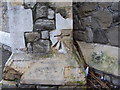
Ordnance Survey bolt on St Saviour's Church
Ordnance Survey bolt on north-east face of north-east buttress at St Saviour's Church, Walmer. This bench mark was established in 1851 during the First primary levelling of England & Wales, and was levelled with a height of 23.129 feet above mean sea level (Liverpool datum). It was included on the London to Dover levelling line, Levelling Mark No. 370.
Image: © Shantavira
Taken: 23 Dec 2011
0.03 miles
9
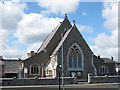
St Saviour's church, Walmer
According to its website, this Anglican church was built in 1848 and reordered in 1980.
Image: © Stephen Craven
Taken: 15 Apr 2012
0.03 miles
10
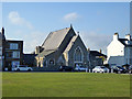
St. Saviour's Church, Walmer
Built 1848.
Image: © Robin Webster
Taken: 14 Oct 2017
0.03 miles