IMAGES TAKEN NEAR TO
York Road, DEAL, CT14 7EA
Introduction
This page details the photographs taken nearby to York Road, CT14 7EA by members of the Geograph project.
The Geograph project started in 2005 with the aim of publishing, organising and preserving representative images for every square kilometre of Great Britain, Ireland and the Isle of Man.

There are currently over 7.5m images from over14,400 individuals and you can help contribute to the project by visiting https://www.geograph.org.uk
Image Map
Images are licensed for reuse under creativecommons.org/licenses/by-sa/2.0
Notes
- Clicking on the map will re-center to the selected point.
- The higher the marker number, the further away the image location is from the centre of the postcode.
Image Listing (209 Images Found)
Images are licensed for reuse under creativecommons.org/licenses/by-sa/2.0
Image
Details
Distance
1
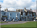
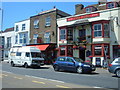
Shops on the Strand
The three shops shown here are a newsagent, estate agent and heating/plumbing supplier.
Image: © Stephen Craven
Taken: 15 Apr 2012
0.02 miles
2
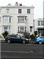
14, The Strand
With a large buddleia growing in the front garden and peeling paint on the window frames, the house looks to have a neglected appearance.
Image: © John Baker
Taken: 5 Mar 2018
0.02 miles
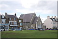
3

The Church of St. Saviour, Lower Walmer
On A258 the Strand.
Image: © David Anstiss
Taken: 24 Apr 2011
0.03 miles
6
Deal, The Stag
The Stag, 7 The Strand, Deal, Kent, CT14 7DY
Image: © Helmut Zozmann
Taken: 14 Jul 2008
0.03 miles
7
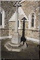
War Memorial at St Saviour's Church, The Strand, Deal
Image: © Ian S
Taken: 11 Feb 2020
0.03 miles
8
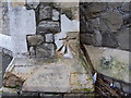
Ordnance Survey bolt on St Saviour's Church
Ordnance Survey bolt on north-east face of north-east buttress at St Saviour's Church, Walmer. This bench mark was established in 1851 during the First primary levelling of England & Wales, and was levelled with a height of 23.129 feet above mean sea level (Liverpool datum). It was included on the London to Dover levelling line, Levelling Mark No. 370.
Image: © Shantavira
Taken: 23 Dec 2011
0.03 miles
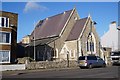
9
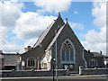
St Saviour's church, Walmer
According to its website, this Anglican church was built in 1848 and reordered in 1980.
Image: © Stephen Craven
Taken: 15 Apr 2012
0.03 miles
10
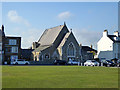
St. Saviour's Church, Walmer
Built 1848.
Image: © Robin Webster
Taken: 14 Oct 2017
0.03 miles