IMAGES TAKEN NEAR TO
Clanwilliam Road, DEAL, CT14 7BX
Introduction
This page details the photographs taken nearby to Clanwilliam Road, CT14 7BX by members of the Geograph project.
The Geograph project started in 2005 with the aim of publishing, organising and preserving representative images for every square kilometre of Great Britain, Ireland and the Isle of Man.

There are currently over 7.5m images from over14,400 individuals and you can help contribute to the project by visiting https://www.geograph.org.uk
Image Map
Images are licensed for reuse under creativecommons.org/licenses/by-sa/2.0
Notes
- Clicking on the map will re-center to the selected point.
- The higher the marker number, the further away the image location is from the centre of the postcode.
Image Listing (606 Images Found)
Images are licensed for reuse under creativecommons.org/licenses/by-sa/2.0
Image
Details
Distance
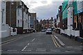
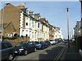
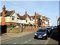
1
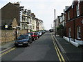
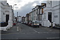
Clanwilliam Road, looking E towards the seafront
Image: © Nick Smith
Taken: 17 Sep 2008
0.01 miles
3
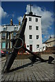
Anchor and Timeball Tower
In the days before wireless communication this tower was used to communicate with ships at sea, the time balls drops every hour. Today the tower houses a museum.
Image: © Philip Halling
Taken: 18 Jul 2009
0.02 miles
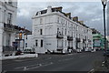
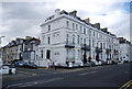
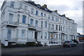
10
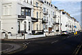
Prince of Wales Terrace, Deal
Stretching away north of the junction with Ranelagh Road, these fine terraces overlook Deal's beach.
Image: © Stephen McKay
Taken: 11 Dec 2021
0.04 miles