IMAGES TAKEN NEAR TO
Victoria Road, DEAL, CT14 7BA
Introduction
This page details the photographs taken nearby to Victoria Road, CT14 7BA by members of the Geograph project.
The Geograph project started in 2005 with the aim of publishing, organising and preserving representative images for every square kilometre of Great Britain, Ireland and the Isle of Man.

There are currently over 7.5m images from over14,400 individuals and you can help contribute to the project by visiting https://www.geograph.org.uk
Image Map
Images are licensed for reuse under creativecommons.org/licenses/by-sa/2.0
Notes
- Clicking on the map will re-center to the selected point.
- The higher the marker number, the further away the image location is from the centre of the postcode.
Image Listing (420 Images Found)
Images are licensed for reuse under creativecommons.org/licenses/by-sa/2.0
Image
Details
Distance
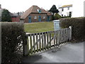
1
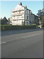
73, Victoria Road
Scaffolding has been erected, on the southeast end of the house, so that attention may be given to the brickwork that was underneath the rendering.
Image: © John Baker
Taken: 13 Dec 2014
0.00 miles
2
73, Victoria Road
Compared with Image, the southeast end of the house now looks to be in a pristine condition.
Image: © John Baker
Taken: 17 May 2015
0.00 miles
4
Derelict-looking building, Victoria Road
It is situated next to a house called The Bungalow and has several hip tiles missing from the roof.
Image: © John Baker
Taken: 20 Mar 2016
0.01 miles
5
Re-roofing an outbuilding, Victoria Road
It lies in the grounds of a house called The Bungalow and just under a year ago was a Image
Image: © John Baker
Taken: 26 Feb 2017
0.01 miles
6
Recently restored outbuilding, Victoria Road
It lies in the grounds of a house called The Bungalow and just over a year ago was undergoing a Image
Image: © John Baker
Taken: 5 Mar 2018
0.01 miles
7
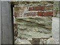
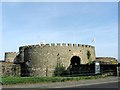
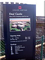
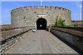
Ordnance Survey bolt at Deal Castle
Ordnance Survey bolt benchmark on the west face of the northern gatepost at the entrance to Deal Castle. This bench mark was established in 1851 during the First primary levelling of England & Wales, and was levelled with a height of 20.9340 feet [6.3807 metres] above mean sea level (Liverpool datum). It was included on the London to Dover levelling line. The surveyor's description was "No. 368. Bolt in corner of wall at entrance to Deal Castle ; 2.17 ft. above surface (p197)." The chiselled OS broad arrow has completely eroded away, but the bolt with its horizontal datum line (centre of photo) has survived.
Image: © Shantavira
Taken: 8 Aug 2012
0.02 miles