IMAGES TAKEN NEAR TO
Walcheren Close, DEAL, CT14 6TY
Introduction
This page details the photographs taken nearby to Walcheren Close, CT14 6TY by members of the Geograph project.
The Geograph project started in 2005 with the aim of publishing, organising and preserving representative images for every square kilometre of Great Britain, Ireland and the Isle of Man.

There are currently over 7.5m images from over14,400 individuals and you can help contribute to the project by visiting https://www.geograph.org.uk
Image Map
Images are licensed for reuse under creativecommons.org/licenses/by-sa/2.0
Notes
- Clicking on the map will re-center to the selected point.
- The higher the marker number, the further away the image location is from the centre of the postcode.
Image Listing (70 Images Found)
Images are licensed for reuse under creativecommons.org/licenses/by-sa/2.0
Image
Details
Distance

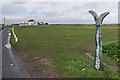
5
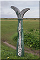
National Cycle Network sign, Golf Road
National Cycle Network sign where Golf Road leaves Deal. Golf Road forms part of National Cycle Network Route 1.
Image: © Ian Capper
Taken: 25 Jan 2014
0.10 miles
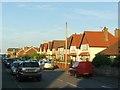
6
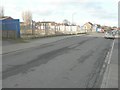
Golf Road
Golf Road alongside the Royal Cinque Ports Golf Links. In the left distance is the clubhouse (see Image) and on the right is the National Cycle Network sign in Image
Image: © Ian Capper
Taken: 25 Jan 2014
0.10 miles
9
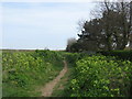
Footpath to Sandown Castle
This path leads from Golf Road past Royal Cinque Ports Golf Course (on the left) towards the ruins of the castle on the sea wall.
Image: © David Anstiss
Taken: 10 Apr 2011
0.15 miles
10
Derelict site, College Road
This site, which was formerly occupied by Bede and Dunstan Houses (residential homes), is to be developed. Planning permission has been granted by Dover District Council under application number DOV/13/00522 for the “erection of 16 dwellings, cycle and bin stores, construction of access road and vehicular access, associated car parking and landscaping”.
Image: © John Baker
Taken: 27 Jan 2014
0.16 miles