IMAGES TAKEN NEAR TO
Cannon Street, DEAL, CT14 6QA
Introduction
This page details the photographs taken nearby to Cannon Street, CT14 6QA by members of the Geograph project.
The Geograph project started in 2005 with the aim of publishing, organising and preserving representative images for every square kilometre of Great Britain, Ireland and the Isle of Man.

There are currently over 7.5m images from over14,400 individuals and you can help contribute to the project by visiting https://www.geograph.org.uk
Image Map
Images are licensed for reuse under creativecommons.org/licenses/by-sa/2.0
Notes
- Clicking on the map will re-center to the selected point.
- The higher the marker number, the further away the image location is from the centre of the postcode.
Image Listing (254 Images Found)
Images are licensed for reuse under creativecommons.org/licenses/by-sa/2.0
Image
Details
Distance
2
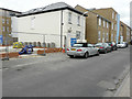
Erection of a building at 25, Cannon Street
Planning permission has been granted by Dover District Council under application number DOV/13/00669 for the “erection of a detached building incorporating two flats, with storeroom under for cycles and electric mobility scooters and alterations to approved parking layout for phase 6 of planning permission granted under DOV/09/0873”. The building site can also be seen in Image
This image shows Image after the work had been completed.
Image: © John Baker
Taken: 4 Sep 2016
0.03 miles
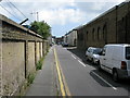
4
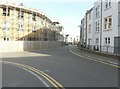
Looking west-southwest along Cannon Street
Compared with Image, taken in December 2013, scaffolding has now been erected on the frontage of number 23 while, beyond it, a building has appeared above the blue hoarding.
Image: © John Baker
Taken: 2 Jul 2014
0.04 miles
5
Looking northeast across Out Downs
The new houses, in the process of being built, have the same name as this road.
Image: © John Baker
Taken: 27 Jan 2014
0.05 miles
6
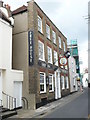
The Ship Inn. 141 Middle Street
A popular free house in Deal.
Image: © pam fray
Taken: 25 Jul 2009
0.05 miles
7
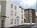
The house where Charles Hawtrey lived, Middle Street
The blue plaque on the left of the building states that "Charles Hawtrey 1914-1988 Film, Theatre, Radio and Television Actor Lived Here".
Image: © pam fray
Taken: 25 Jul 2009
0.05 miles
8
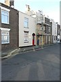
43 College Road
This is the house where scaffolding has been erected on its frontage as far as the second storey.
Image: © John Baker
Taken: 27 Jan 2014
0.05 miles
9
Looking east along Out Downs
The new houses, in the process of being built, have the same name as this road.
Image: © John Baker
Taken: 27 Jan 2014
0.06 miles
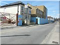
10
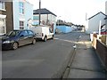
Looking west-southwest along Cannon Street
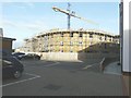
The blue hoarding hides a building site. Planning permission has been granted by Dover District Council under application number DOV/09/00873 for the “erection of a GP surgery, Community Centre, 28 flats and 41 houses, related infrastructure and car parking”.
Image: © John Baker
Taken: 10 Nov 2013
0.07 miles