IMAGES TAKEN NEAR TO
Northwall Road, DEAL, CT14 6PN
Introduction
This page details the photographs taken nearby to Northwall Road, CT14 6PN by members of the Geograph project.
The Geograph project started in 2005 with the aim of publishing, organising and preserving representative images for every square kilometre of Great Britain, Ireland and the Isle of Man.

There are currently over 7.5m images from over14,400 individuals and you can help contribute to the project by visiting https://www.geograph.org.uk
Image Map (Loading...)


Getting Data...Please wait
Leaflet Map data © OpenStreetMap
Images are licensed for reuse under creativecommons.org/licenses/by-sa/2.0
Notes
- Clicking on the map will re-center to the selected point.
- The higher the marker number, the further away the image location is from the centre of the postcode.
Image Listing (235 Images Found)
Images are licensed for reuse under creativecommons.org/licenses/by-sa/2.0
Image
Details
Distance
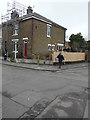
3
75, Western Road
This was Image during the building of the extension.
Image: © John Baker
Taken: 12 May 2019
0.05 miles
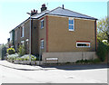
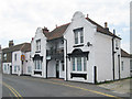
4
75, Western Road
Planning permission has been granted by Dover District Council under application number DOV/16/00467 for the “erection of a two storey side extension”. The house also stands on the corner of Northwall Road.
This was Image after the extension had been completed.
Image: © John Baker
Taken: 5 Feb 2017
0.06 miles
6
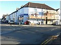
Corner store
Situated on the corner of Ark Lane and Western Road, it appears that scaffolding has been erected to enable repainting of this side of the building.
Image: © John Baker
Taken: 10 Nov 2013
0.06 miles
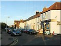
7
Building to let on Golf Road
Unusual Dutch gable styled front elevation.
Image: © Oast House Archive
Taken: 24 Jul 2010
0.06 miles
8
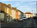
Terrace of houses in Ark Lane
Planning permission has been granted by Dover District Council under application number DOV/11/00430 for the “change of use and conversion to a single residential dwelling”. The permission relates to number 35, which is the house at this end of the terrace. Previously, it was a carpet and blind centre.
This shows the Image after work on number 35 had been completed.
Image: © John Baker
Taken: 10 Nov 2013
0.07 miles
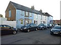
9
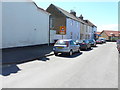
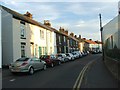
Terrace of houses in Ark Lane
The conversion of number 35 (the house nearest to the camera) has been completed in the Image, as all traces of the building work have been hidden under blue-painted render.
Image: © John Baker
Taken: 12 May 2019
0.07 miles
10
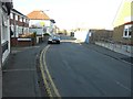
Looking north-northeast along Golf Road
On the left is the nameplate for Sandown Court, while on the opposite side of the road is hoarding that hides a building site. Planning permission has been granted by Dover District Council under application number DOV/09/00873 for the “erection of a GP surgery, Community Centre, 28 flats and 41 houses, related infrastructure and car parking”.
Image: © John Baker
Taken: 10 Nov 2013
0.09 miles