IMAGES TAKEN NEAR TO
Sandown Road, DEAL, CT14 6NY
Introduction
This page details the photographs taken nearby to Sandown Road, CT14 6NY by members of the Geograph project.
The Geograph project started in 2005 with the aim of publishing, organising and preserving representative images for every square kilometre of Great Britain, Ireland and the Isle of Man.

There are currently over 7.5m images from over14,400 individuals and you can help contribute to the project by visiting https://www.geograph.org.uk
Image Map
Images are licensed for reuse under creativecommons.org/licenses/by-sa/2.0
Notes
- Clicking on the map will re-center to the selected point.
- The higher the marker number, the further away the image location is from the centre of the postcode.
Image Listing (182 Images Found)
Images are licensed for reuse under creativecommons.org/licenses/by-sa/2.0
Image
Details
Distance
1
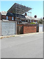
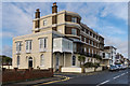
36, The Marina
Planning permission has been granted by Dover District Council under application number DOV/18/01240 for a “Certificate of Lawfulness (proposed) for the erection of a rear dormer roof extension and installation of 2 roof lights to front roof slope”.
Image: © John Baker
Taken: 12 May 2019
0.03 miles
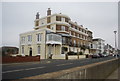
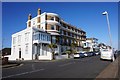
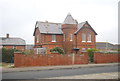
5
40 - 44 The Marina
Old maps suggest that this building was one of the earliest on The Marina, being shown on the 1872 1:2500 map as Sandown Terrace.
Image: © Ian Capper
Taken: 25 Jan 2014
0.05 miles
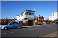
10
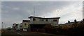
The Coastguard station, Deal
On Beach Street.
Image: © Steve Fareham
Taken: 4 Mar 2009
0.06 miles