IMAGES TAKEN NEAR TO
The Marina, DEAL, CT14 6NR
Introduction
This page details the photographs taken nearby to The Marina, CT14 6NR by members of the Geograph project.
The Geograph project started in 2005 with the aim of publishing, organising and preserving representative images for every square kilometre of Great Britain, Ireland and the Isle of Man.

There are currently over 7.5m images from over14,400 individuals and you can help contribute to the project by visiting https://www.geograph.org.uk
Image Map
Images are licensed for reuse under creativecommons.org/licenses/by-sa/2.0
Notes
- Clicking on the map will re-center to the selected point.
- The higher the marker number, the further away the image location is from the centre of the postcode.
Image Listing (89 Images Found)
Images are licensed for reuse under creativecommons.org/licenses/by-sa/2.0
Image
Details
Distance
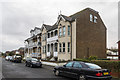
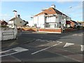
4
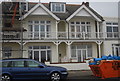
Hollowell House
A late Victorian building on Sandown Road. It, along with nos 151 - 155 (see Image), is shown on the 1898 1:2500 map in an otherwise largely undeveloped road; it's not until the 1957 equivalent map that there is any significant development in that section of the road.
Image: © Ian Capper
Taken: 25 Jan 2014
0.02 miles
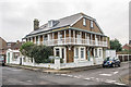
5
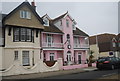
151 - 155 Sandown Road
A pair of late Victorian buildings on Sandown Road (the far one, nos 151/153, is semi-detached, and the near one, no 155, is detached - both buildings are now divided into flats). They, along with Hollowell House (see Image), are shown on the 1898 1:2500 map in an otherwise largely undeveloped road; it's not until the 1957 equivalent map that there is any significant development in that section of the road.
Image: © Ian Capper
Taken: 25 Jan 2014
0.03 miles
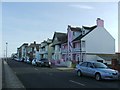
6
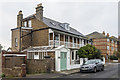
Hollowell House
A late Victorian building on Sandown Road. It, along with nos 151 - 155 (see Image), is shown on the 1898 1:2500 map in an otherwise largely undeveloped road; it's not until the 1957 equivalent map that there is any significant development in that section of the road.
On the right is Harold Road, one of a number of roads in this part of Deal named after Saxon/Viking kings. On the 1898 map it is shown as Wakeham's Road; the 1907 map shows it with its current name.
Image: © Ian Capper
Taken: 25 Jan 2014
0.03 miles
8
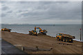
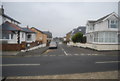
Deal sea defence scheme
Work under way recharging Deal beach with shingle as part of a sea defence scheme.
Image: © Ian Capper
Taken: 25 Jan 2014
0.04 miles
9
203 Sandown Road
The scaffolding suggests that work is being carried out to the exterior of the house.
Image: © John Baker
Taken: 27 Jan 2014
0.04 miles
10
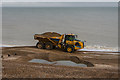
Deal sea defence scheme
Work under way recharging Deal beach with shingle as part of a sea defence scheme.
Image: © Ian Capper
Taken: 25 Jan 2014
0.04 miles