IMAGES TAKEN NEAR TO
The Marina, DEAL, CT14 6NG
Introduction
This page details the photographs taken nearby to The Marina, CT14 6NG by members of the Geograph project.
The Geograph project started in 2005 with the aim of publishing, organising and preserving representative images for every square kilometre of Great Britain, Ireland and the Isle of Man.

There are currently over 7.5m images from over14,400 individuals and you can help contribute to the project by visiting https://www.geograph.org.uk
Image Map
Images are licensed for reuse under creativecommons.org/licenses/by-sa/2.0
Notes
- Clicking on the map will re-center to the selected point.
- The higher the marker number, the further away the image location is from the centre of the postcode.
Image Listing (241 Images Found)
Images are licensed for reuse under creativecommons.org/licenses/by-sa/2.0
Image
Details
Distance
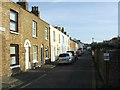
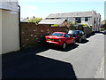
7

Sheltered Street, off Beach Street, Deal
The Conservation area in Deal between Middle Street and Beach Street has many narrow cross streets, well sheltered from the East wind and blissfully devoid of cars too.
Image: © Dr Duncan Pepper
Taken: 22 Apr 2006
0.02 miles
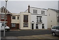
9
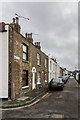
Bulwark Road
Terraced housing on a Street off Hengist Road running parallel to Sandown Road. These cottages are shown on the 1873 1:500 town plan as Bulwark Row; it would seem that is not until later that the street itself acquired its current name.
Image: © Ian Capper
Taken: 25 Jan 2014
0.03 miles