IMAGES TAKEN NEAR TO
St. Patricks Road, DEAL, CT14 6AW
Introduction
This page details the photographs taken nearby to St. Patricks Road, CT14 6AW by members of the Geograph project.
The Geograph project started in 2005 with the aim of publishing, organising and preserving representative images for every square kilometre of Great Britain, Ireland and the Isle of Man.

There are currently over 7.5m images from over14,400 individuals and you can help contribute to the project by visiting https://www.geograph.org.uk
Image Map
Images are licensed for reuse under creativecommons.org/licenses/by-sa/2.0
Notes
- Clicking on the map will re-center to the selected point.
- The higher the marker number, the further away the image location is from the centre of the postcode.
Image Listing (339 Images Found)
Images are licensed for reuse under creativecommons.org/licenses/by-sa/2.0
Image
Details
Distance
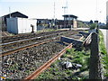
1
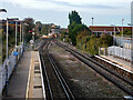
Looking north from Deal station
With the Western Road level crossing and extant signal box in view.
Image: © John Lucas
Taken: 13 Oct 2023
0.04 miles
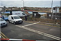
4
Signal box and level crossing on the Deal line
Image: © Nick Smith
Taken: 9 Feb 2008
0.06 miles
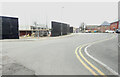
5
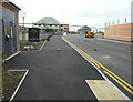
Court Marsh Road, Pottery Grove
Planning permission has been granted by Dover District Council under application number DOV/15/01290 for an “outline application for a mixed-use development incorporating 142 residential units, 960sqm B1 Office, 370sqm of A1, 280sqm of D1 and a link road between Albert Road and Southwall Road (some matters reserved)”.
Pottery Grove is the name, which has been given to this housing estate.
Image: © John Baker
Taken: 18 Oct 2020
0.06 miles
6
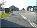
Court Marsh Road, Pottery Grove
This was Image in October 2020.
Pottery Grove is the name, which has been given to this housing estate.
Image: © John Baker
Taken: 5 Sep 2021
0.07 miles
7

Lydden Close, Pottery Grove
Pottery Grove is the name, which has been given to this housing estate.
Image: © John Baker
Taken: 5 Sep 2021
0.07 miles
8
Lydden Close, Pottery Grove
Pottery Grove is the name, which has been given to this housing estate.
Image: © John Baker
Taken: 12 Feb 2023
0.07 miles