IMAGES TAKEN NEAR TO
Church Path, DEAL, CT14 0HH
Introduction
This page details the photographs taken nearby to Church Path, CT14 0HH by members of the Geograph project.
The Geograph project started in 2005 with the aim of publishing, organising and preserving representative images for every square kilometre of Great Britain, Ireland and the Isle of Man.

There are currently over 7.5m images from over14,400 individuals and you can help contribute to the project by visiting https://www.geograph.org.uk
Image Map
Images are licensed for reuse under creativecommons.org/licenses/by-sa/2.0
Notes
- Clicking on the map will re-center to the selected point.
- The higher the marker number, the further away the image location is from the centre of the postcode.
Image Listing (96 Images Found)
Images are licensed for reuse under creativecommons.org/licenses/by-sa/2.0
Image
Details
Distance
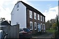
2
Stable block conversion, Mongeham Road
Planning permission has been granted by Dover District Council under application number DOV/11/01141 for the “conversion of existing stable block into annexe accommodation, incorporating a pitched roof and other external alterations and the erection of an outbuilding for a hobby room and garage (following the demolition of an existing timber barn)”. The building forms a part of the property known as Champlains Well.
The site can also be seen when Image
Image: © John Baker
Taken: 23 Oct 2016
0.04 miles
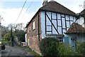
3
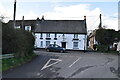
Cottages along Mongeham Road
Taken from the road's junction with Ellen's Hill and showing a small section of Lamp Cottage.
Image: © John Baker
Taken: 5 Sep 2012
0.04 miles
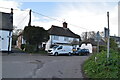
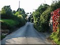
7
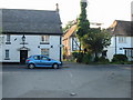
Junction of Ellens Road with Mongeham Road
Image: © Nick Smith
Taken: 19 Sep 2008
0.04 miles
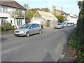
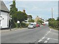
8
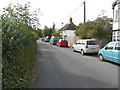
Looking southwest along Mongeham Road
The view shows where an existing stable block is being converted. Planning permission has been granted by Dover District Council under application number DOV/11/01141 for the “conversion of existing stable block into annexe accommodation, incorporating a pitched roof and other external alterations and the erection of an outbuilding for a hobby room and garage (following the demolition of an existing timber barn)”. The building forms a part of the property known as Champlains Well.
Image: © John Baker
Taken: 4 Sep 2016
0.05 miles