IMAGES TAKEN NEAR TO
CT14 0FL
Introduction
This page details the photographs taken nearby to CT14 0FL by members of the Geograph project.
The Geograph project started in 2005 with the aim of publishing, organising and preserving representative images for every square kilometre of Great Britain, Ireland and the Isle of Man.

There are currently over 7.5m images from over14,400 individuals and you can help contribute to the project by visiting https://www.geograph.org.uk
Image Map
Images are licensed for reuse under creativecommons.org/licenses/by-sa/2.0
Notes
- Clicking on the map will re-center to the selected point.
- The higher the marker number, the further away the image location is from the centre of the postcode.
Image Listing (35 Images Found)
Images are licensed for reuse under creativecommons.org/licenses/by-sa/2.0
Image
Details
Distance
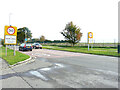
1

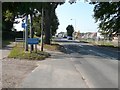
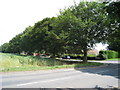
London Road
Heading out of Deal towards Sandwich.
Image: © Oast House Archive
Taken: 24 Jul 2010
0.02 miles
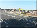
2
Looking towards the Sholden Fields building site
On 15 November 2011, it was reported on the thisiskent website that residents of Sholden had reacted furiously to a Dover District Council’s decision to allow 460 new homes to be built in their village. This shows the site that Ward is building beside the A258 (London Road) and Sholden New Road http://www.thisiskent.co.uk/Villagers-dismayed-plan-460-homes-Sholden/story-14145753-detail/story.html#axzz2ehS0g3qq
Image: © John Baker
Taken: 27 Aug 2013
0.03 miles
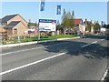
3
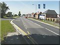
Bus stop, London Road (A258)
It (and a lights-controlled pedestrian crossing) is ideally situated for the Sholden Fields housing development, on the opposite side of the road. However the pavement, that runs along beside the new houses, has the laid with a slope at the point opposite the red car. One can only imagine what it will be like in icy weather…
Image: © John Baker
Taken: 2 Jul 2014
0.04 miles
4
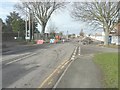
Traffic control, London Road (A258)
Seen from near to the junction with Sholden New Road, the road surface is being excavated and replaced following local complaints about its uneven surface, potholes and the mud deposited by contractors’ vehicles from the Sholden Fields housing estate. This is in the process of being built and can be partly seen on the right.
Image: © John Baker
Taken: 27 Jan 2014
0.05 miles
5
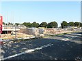
Sholden Fields building site
On 15 November 2011, it was reported on the thisiskent website that residents of Sholden had reacted furiously to a Dover District Council’s decision to allow 460 new homes to be built in their village. This shows the site that Ward is building beside the A258 (London Road) and Sholden New Road (marked by the line of trees in this view) http://www.thisiskent.co.uk/Villagers-dismayed-plan-460-homes-Sholden/story-14145753-detail/story.html#axzz2ehS0g3qq
Image: © John Baker
Taken: 27 Aug 2013
0.05 miles
7
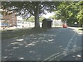
Bus stop in Sholden New Road
It is situated almost opposite Paddock Close, whose entrance can be seen on the right. Number 13 and 13A buses stop here on their ways from Sandwich. Behind the bus stop is the Sholden Fields housing development; this part is still under construction.
Image: © John Baker
Taken: 2 Jul 2014
0.07 miles
8
Sholden Fields building site
On 15 November 2011, it was reported on the thisiskent website that residents of Sholden had reacted furiously to a Dover District Council’s decision to allow 460 new homes to be built in their village. This shows the site that Ward is building beside the A258 (London Road) and Sholden New Road http://www.thisiskent.co.uk/Villagers-dismayed-plan-460-homes-Sholden/story-14145753-detail/story.html#axzz2ehS0g3qq
Image: © John Baker
Taken: 27 Aug 2013
0.08 miles
9
Sholden Fields building site
On 15 November 2011, it was reported on the thisiskent website that residents of Sholden had reacted furiously to a Dover District Council’s decision to allow 460 new homes to be built in their village. This shows the site that Ward is building beside the A258 (London Road) and Sholden New Road http://www.thisiskent.co.uk/Villagers-dismayed-plan-460-homes-Sholden/story-14145753-detail/story.html#axzz2ehS0g3qq
Image: © John Baker
Taken: 27 Aug 2013
0.08 miles
10
Development land, Sandwich Road (A258)
Planning permission has been approved by Dover District Council under application number DOV/21/00402 for an “outline application for the erection of up to 110 dwellings with associated parking and means of access (all matters reserved except for access)”.
The land lies beyond the footpath on the right.
Image: © John Baker
Taken: 23 Oct 2022
0.09 miles