IMAGES TAKEN NEAR TO
Worth, DEAL, CT14 0DH
Introduction
This page details the photographs taken nearby to CT14 0DH by members of the Geograph project.
The Geograph project started in 2005 with the aim of publishing, organising and preserving representative images for every square kilometre of Great Britain, Ireland and the Isle of Man.

There are currently over 7.5m images from over14,400 individuals and you can help contribute to the project by visiting https://www.geograph.org.uk
Image Map (Loading...)


Getting Data...Please wait
Leaflet Map data © OpenStreetMap
Images are licensed for reuse under creativecommons.org/licenses/by-sa/2.0
Notes
- Clicking on the map will re-center to the selected point.
- The higher the marker number, the further away the image location is from the centre of the postcode.
Image Listing (15 Images Found)
Images are licensed for reuse under creativecommons.org/licenses/by-sa/2.0
Image
Details
Distance
1
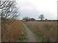
White Cliffs Country Trail towards Stuart's Folly (2)
The long distance path leads along a footpath from Dover Road, Sandwich towards Stuart's Folly (the house in the background). Then it heads via bridleway to Goretop Lane, past Temptye Farm.
Image: © David Anstiss
Taken: 13 Feb 2011
0.04 miles
2
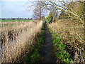
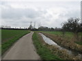
Footpath towards Sandwich
A series of tarmac footpaths can be found around Sandwich. This one is approaching Sandwich and its station from Worth. After a long spell of wet weather, and more rain overnight, many fields had become waterlogged. Nearby examples on the same day can be seen at http://www.geograph.org.uk/photo/3826810 and http://www.geograph.org.uk/photo/3826458 so walking through fields on a solid surface like this with drainage ditches on either side was much appreciated.
Image: © Marathon
Taken: 25 Jan 2014
0.09 miles
3
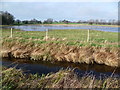
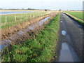
View from the White Cliffs Country Trail near Worth
The White Cliffs Trails were created in 1987 by Dover District Council to link the towns of Dover, Deal and Sandwich, going along the white cliffs to the east of Dover to Deal with an inland return through the Kent countryside to include Sandwich. See http://www.bertuchi.co.uk/whitecliff03.php for some photographs of this part of the Trail.
This section follows a tarmac road north-west of Temptye Farm and Little Temptye. After a long spell of wet weather, and more rain overnight, many fields had become waterlogged as can be seen here.
Image: © Marathon
Taken: 25 Jan 2014
0.09 miles
4
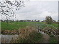
Footbridge on the White Cliffs Country Trail
The long distance path leads from Stuart's Folly (house near Worth) towards Dover Road in Sandwich. It passes over the Delf (drainage channel) leading left towards Sandwich from the Lydden Valley.
Image: © David Anstiss
Taken: 13 Feb 2011
0.11 miles
5
White Cliffs Country Trail towards Stuart's Folly
The long distance path leads along a bridleway (beside Delf - drainage channel ) from Goretop Lane, past Temptye Farm towards Stuart's Folly (cottage) and then into Sandwich (via a footpath).
Image: © David Anstiss
Taken: 13 Feb 2011
0.11 miles
6
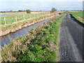
White Cliffs Country Trail near Worth
The White Cliffs Trails were created in 1987 by Dover District Council to link the towns of Dover, Deal and Sandwich, going along the white cliffs to the east of Dover to Deal with an inland return through the Kent countryside to include Sandwich. See http://www.bertuchi.co.uk/whitecliff03.php for some photographs of this part of the Trail.
This section follows a tarmac road towards Temptye Farm and Little Temptye. A train on the line between Sandwich and Deal can be seen in the distance. After a long spell of wet weather, and more rain overnight, many fields had become waterlogged. Nearby examples on the same day can be seen at http://www.geograph.org.uk/photo/3826810 and http://www.geograph.org.uk/photo/3826458 so walking through fields on a solid surface like this was much appreciated.
Image: © Marathon
Taken: 25 Jan 2014
0.13 miles
7
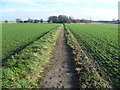
White Cliffs Country Trail near Worth
The White Cliffs Trails were created in 1987 by Dover District Council to link the towns of Dover, Deal and Sandwich, going along the white cliffs to the east of Dover to Deal with an inland return through the Kent countryside to include Sandwich. See http://www.bertuchi.co.uk/whitecliff03.php for some photographs of this part of the Trail.
This section follows a tarmac road towards Temptye Farm and Little Temptye. After a long spell of wet weather, and more rain overnight, many fields had become waterlogged. Nearby examples on the same day can be seen at http://www.geograph.org.uk/photo/3826810 and http://www.geograph.org.uk/photo/3826458 so walking through fields on a solid surface like this was much appreciated.
Image: © Marathon
Taken: 25 Jan 2014
0.14 miles
8
Footpath from Sandwich
A series of tarmac footpaths can be found around Sandwich. This one leads from Sandwich towards Worth. After a long spell of wet weather, and more rain overnight, many fields had become waterlogged. Nearby examples on the same day can be seen at http://www.geograph.org.uk/photo/3826810 and http://www.geograph.org.uk/photo/3826458 so walking through fields on a solid surface like this was much appreciated.
Image: © Marathon
Taken: 25 Jan 2014
0.14 miles
9
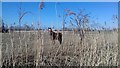
Horse through the reeds
On a freezing but bright morning in late February
Image: © Bikeboy
Taken: 25 Feb 2018
0.15 miles
10

White Cliffs Country Trail near Worth
The White Cliffs Trails were created in 1987 by Dover District Council to link the towns of Dover, Deal and Sandwich, going along the white cliffs to the east of Dover to Deal with an inland return through the Kent countryside to include Sandwich. See http://www.bertuchi.co.uk/whitecliff03.php for some photographs of this part of the Trail.
This section follows a tarmac road towards Temptye Farm, which can be seen in the distance, and Little Temptye. After a long spell of wet weather, and more rain overnight, many fields had become waterlogged. Nearby examples on the same day can be seen at http://www.geograph.org.uk/photo/3826810 and http://www.geograph.org.uk/photo/3826458 so walking through fields on a solid surface like this was much appreciated.
Image: © Marathon
Taken: 25 Jan 2014
0.16 miles