IMAGES TAKEN NEAR TO
Sandwich Road, DEAL, CT14 0AR
Introduction
This page details the photographs taken nearby to Sandwich Road, CT14 0AR by members of the Geograph project.
The Geograph project started in 2005 with the aim of publishing, organising and preserving representative images for every square kilometre of Great Britain, Ireland and the Isle of Man.

There are currently over 7.5m images from over14,400 individuals and you can help contribute to the project by visiting https://www.geograph.org.uk
Image Map
Images are licensed for reuse under creativecommons.org/licenses/by-sa/2.0
Notes
- Clicking on the map will re-center to the selected point.
- The higher the marker number, the further away the image location is from the centre of the postcode.
Image Listing (10 Images Found)
Images are licensed for reuse under creativecommons.org/licenses/by-sa/2.0
Image
Details
Distance
2
![You are here, Betteshanger [Country] Park](https://s0.geograph.org.uk/geophotos/07/10/80/7108096_51b75c99_120x120.jpg)
You are here, Betteshanger [Country] Park
This site was originally Foulmead Marsh, and then the spoil heap for Betteshanger Colliery. The pit opened in the late 1920s and closed in 1989. Fowlmead Park and nature reserve opened here in May 2007. When it was taken over by the Hadlow Group in May 2015, it was renamed Betteshanger Country Park. More recently the 'Country' has been dropped. All these signs say Betteshanger Country Park.
Image: © Christine Johnstone
Taken: 17 Feb 2022
0.07 miles
3
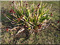
The plants are moving in
A wild iris getting established on Fowlmead Country Park, the spoil heap is gradually becoming covered in vegetation. I think this is probably Iris foetidissima or 'Stinking Iris'.
Image: © Nick Smith
Taken: 27 Jan 2008
0.08 miles
4
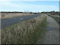
Alder Lake from Fowlmead Park
Alder Lake is part of the Cottington Lakes fisheries for anglers. Viewed from Fowlmead Park, a former coal tip. http://www.fisheries.co.uk/cottington/index.htm
Image: © Nick Smith
Taken: 27 Jan 2008
0.12 miles
5
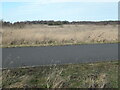
Cottington Court from Fowlmead Country Park
Image: © Nick Smith
Taken: 27 Jan 2008
0.14 miles
6
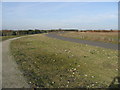
Tarmac cycle track and leisure path
This site was originally Foulmead Marsh, and then the spoil heap for Betteshanger Colliery. The pit opened in the late 1920s and closed in 1989. Fowlmead Park and nature reserve opened here in May 2007. When it was taken over by the Hadlow Group in May 2015, it was renamed Betteshanger Country Park. More recently the 'Country' has been dropped. The tarmac track is just for cyclists, the path from walkers and cyclists.
Image: © Christine Johnstone
Taken: 17 Feb 2022
0.14 miles
7
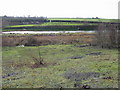
Black Lake from Fowlmead Country Park
The lake is part of the Cottington Lakes coarse fisheries and the photograph is taken from the spoil heap of Betteshanger colliery which has been made into a country park. http://www.fowlmead.co.uk/
Image: © Nick Smith
Taken: 27 Jan 2008
0.22 miles
8
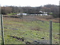
Black Lake, one of the Cottington fishing lakes
Viewed from Fowlmead park, a former coal waste tip.
Image: © Nick Smith
Taken: 27 Jan 2008
0.22 miles
9
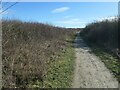
Leisure path, west of 'The Meadow'
This site was originally Foulmead Marsh, and then the spoil heap for Betteshanger Colliery. The pit opened in the late 1920s and closed in 1989. Fowlmead Park and nature reserve opened here in May 2007. When it was taken over by the Hadlow Group in May 2015, it was renamed Betteshanger Country Park. More recently the 'Country' has been dropped. Leisure paths are for walkers and cyclists.
Image: © Christine Johnstone
Taken: 17 Feb 2022
0.22 miles
10
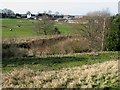
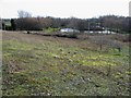
'The Meadow', Betteshanger [Country] Park
This site was originally Foulmead Marsh, and then the spoil heap for Betteshanger Colliery. The pit opened in the late 1920s and closed in 1989. Fowlmead Park and nature reserve opened here in May 2007. When it was taken over by the Hadlow Group in May 2015, it was renamed Betteshanger Country Park. More recently the 'Country' has been dropped. Most of the eastern side of the park is wooded, most of this western side is not.
Image: © Christine Johnstone
Taken: 17 Feb 2022
0.24 miles