IMAGES TAKEN NEAR TO
George Roche Road, CANTERBURY, CT1 3LP
Introduction
This page details the photographs taken nearby to George Roche Road, CT1 3LP by members of the Geograph project.
The Geograph project started in 2005 with the aim of publishing, organising and preserving representative images for every square kilometre of Great Britain, Ireland and the Isle of Man.

There are currently over 7.5m images from over14,400 individuals and you can help contribute to the project by visiting https://www.geograph.org.uk
Image Map
Images are licensed for reuse under creativecommons.org/licenses/by-sa/2.0
Notes
- Clicking on the map will re-center to the selected point.
- The higher the marker number, the further away the image location is from the centre of the postcode.
Image Listing (43 Images Found)
Images are licensed for reuse under creativecommons.org/licenses/by-sa/2.0
Image
Details
Distance
1
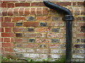
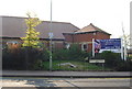
Ordnance Survey bolt on former Canterbury Workhouse
Ordnance Survey bench mark with centre bolt on the north-east face of the former Canterbury Workhouse, now an apartment building called Nunnery Fields, off George Roche Road. This bench mark was established in 1850 or 1851 during the First primary levelling of England & Wales, and was levelled with a height of 126.9150 feet [38.6837 metres] above mean sea level (Liverpool datum). It was included as a side level on the London to Dover levelling line. The surveyor's description was No. 263(g). Canterbury Union Workhouse. Bolt in North-east corner; 1.51 ft. above surface (p193). Repointing has obscured the original mark, but the centre bolt is clearly visible four courses above ground level.
Image: © Shantavira
Taken: 8 Aug 2012
0.03 miles
2
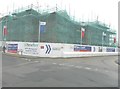
Millers Court, George Roche Road
A development of 2 bedroom apartments built by Taylor Wimpey http://www.taylorwimpey.co.uk/newhomes/south+east/millerscourt/
Image: © John Baker
Taken: 10 Mar 2013
0.06 miles
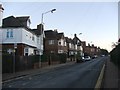
3
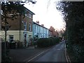
New housing development on South Canterbury Rd.
Redevelopment on the site of an old chapel
Image: © N Chadwick
Taken: 27 Sep 2008
0.06 miles
5
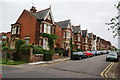
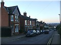
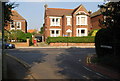
Cromwell Road, Canterbury
A residential street viewed from the Puckle Lane end.
Image: © Bill Boaden
Taken: 27 Jun 2012
0.09 miles
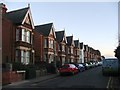
7
The end of Stuppington Lane, Canterbury
Outer suburbs of Canterbury.
Image: © N Chadwick
Taken: 27 Sep 2008
0.10 miles
8
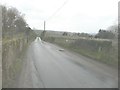
Parapets of a bridge, Stuppington Lane
The bridge once carried the road over the Elham Valley Railway, which closed in 1948. There is a deep, overgrown cutting to the left of the bridge, but this has been infilled to the right of it.
Image: © John Baker
Taken: 10 Mar 2013
0.10 miles