IMAGES TAKEN NEAR TO
Orchard Mews, CANTERBURY, CT1 3FT
Introduction
This page details the photographs taken nearby to Orchard Mews, CT1 3FT by members of the Geograph project.
The Geograph project started in 2005 with the aim of publishing, organising and preserving representative images for every square kilometre of Great Britain, Ireland and the Isle of Man.

There are currently over 7.5m images from over14,400 individuals and you can help contribute to the project by visiting https://www.geograph.org.uk
Image Map
Images are licensed for reuse under creativecommons.org/licenses/by-sa/2.0
Notes
- Clicking on the map will re-center to the selected point.
- The higher the marker number, the further away the image location is from the centre of the postcode.
Image Listing (43 Images Found)
Images are licensed for reuse under creativecommons.org/licenses/by-sa/2.0
Image
Details
Distance
1
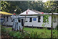
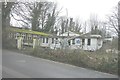
Sea cadets hut & gun, Puckle Lane
This looks very much like a deck gun from a submarine.
Image: © N Chadwick
Taken: 27 Sep 2008
0.12 miles
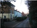
2
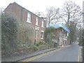
10 and 12 Puckle Lane
The nearer house (number 12) is also called Canon House; number 10 is beyond. Planning permission has been granted by Canterbury City Council under application number CA/13/00177 for the “conversion of existing building for 5 residential units with associated parking and amenity areas”.
Image: © John Baker
Taken: 10 Mar 2013
0.13 miles
3
10 Puckle Lane
Viewed from Raymond Avenue, planning permission has been granted by Canterbury City Council under application number CA//13/00177 for the “conversion of existing building for 5 residential units with associated parking and amenity areas”.
Image: © John Baker
Taken: 10 Mar 2013
0.13 miles
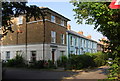
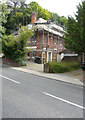
6
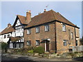
No.81 Old Dover Road, Canterbury
A Grade II listed house, part of a group of listed houses on the road.
This one is also called 'The Oast'.
See http://www.britishlistedbuildings.co.uk/en-440162-81a-old-dover-road-kent for more details about the building.
Image: © David Anstiss
Taken: 17 Feb 2013
0.14 miles
7
The end of Stuppington Lane, Canterbury
Outer suburbs of Canterbury.
Image: © N Chadwick
Taken: 27 Sep 2008
0.14 miles
8
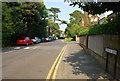
Puckle Lane
Suburban street in South Canterbury.
Image: © N Chadwick
Taken: 27 Sep 2008
0.14 miles
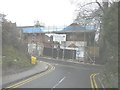
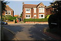
9
Former Canterbury sea cadets HQ, Puckle Lane
The blue notice attached to the building reads "Canterbury sea cadets HMS Courageous". Nigel Chadwick's picture shows the building when it was in use Image Now the sea cadets have moved out of these premises and are hoping to move into a new unit in Vauxhall Road, Canterbury when they have obtained planning permission http://www.sea-cadets.org/canterbury/about-our-unit.aspx which has been granted by Canterbury City Council under application number CA//11/01522 for “the erection of a sea cadets headquarters building and associated facilities”.
Image: © John Baker
Taken: 10 Mar 2013
0.14 miles
10
Ongoing alterations to 78, Old Dover Road
Planning permission has been granted by Canterbury City Council under application number CA//14/01981 for the “demolition of garage, erection of two and one-storey extension at side, extension of second floor rear dormer window”.
Image: © John Baker
Taken: 10 Jul 2016
0.14 miles