1
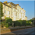
Canterbury houses [146]
The Hoystings, number 56 Old Dover Road, is an early 18th century classical house that has been Gothicized in the early 19th century. Constructed of red brick under a tile roof. All the windows, including the dormers, have obtusely pointed heads and Gothic divisions. There is a stuccoed Gothic doorway with cornice and parapet. There is a 19th century extension on the garden side. Now apartments. Listed, grade II*, with details at: https://historicengland.org.uk/listing/the-list/list-entry/1260634
Canterbury is a small historic city on the River Stour in Kent, some 54 miles southeast of London. Occupied since prehistoric times, it became an important Roman city. In 672, the see of Canterbury gained authority over the entire English Church. After the murder of Archbishop Thomas Becket at the cathedral in 1170, pilgrims from all parts of Christendom came to visit his shrine until the Dissolution. Today, Canterbury is a popular tourist destination and one of the most-visited cities in the United Kingdom. The city has a substantial student population, with four university campuses.
Image: © Michael Dibb
Taken: 7 Sep 2021
0.03 miles
2
St Mary Bredin under Construction
Canterbury Church on junction of Old Dover Road and Nunnery Fields.
Photo taken on Nunnery Fields Road. Construction Project includes upgrading the Kendal Hall and the Church/Church Centre.
About the project see link http://www.smb.org.uk
Image: © David Anstiss
Taken: 16 Nov 2008
0.04 miles
3
68, Old Dover Road
Planning permission has been granted by Canterbury City Council under application number CA/20/02186 for a "three-storey building with a basement, comprising 27 student apartments (including warden's accommodation) with communal facilities including cycle and refuse storage, amenity areas and three 'operational' parking spaces for service/maintenance vehicles, following demolition of the existing dwelling and a garage".
Taken during a photographic outing on Christmas Day afternoon.
Image: © John Baker
Taken: 25 Dec 2022
0.04 miles
4
68, Old Dover Road
As the ‘to let’ board indicates, this is student accommodation.
Image: © John Baker
Taken: 10 Jul 2016
0.04 miles
5
House construction, Puckle Lane
Planning permission was granted by Canterbury City Council under application number CA//15/01251 for “the re-development of the site to create three detached dwellings, with associated parking, access and landscaping”. They have been built on the site of the
Image
Image: © John Baker
Taken: 21 Oct 2018
0.06 miles
6
Two Doves, Canterbury
Image: © Chris Whippet
Taken: 28 Dec 2014
0.06 miles
7
Nunnery Fields, Canterbury
Image: © Chris Whippet
Taken: 28 Dec 2014
0.06 miles
8
Canterbury houses [140]
Numbers 5 to 14 Nunnery Fields are a terrace of 10 houses dated 1827 with a later extension. Constructed of red brick, with some stucco and some weatherboarding, under a tile roof. Listed, grade II, with details at: https://historicengland.org.uk/listing/the-list/list-entry/1241182
Canterbury is a small historic city on the River Stour in Kent, some 54 miles southeast of London. Occupied since prehistoric times, it became an important Roman city. In 672, the see of Canterbury gained authority over the entire English Church. After the murder of Archbishop Thomas Becket at the cathedral in 1170, pilgrims from all parts of Christendom came to visit his shrine until the Dissolution. Today, Canterbury is a popular tourist destination and one of the most-visited cities in the United Kingdom. The city has a substantial student population, with four university campuses.
Image: © Michael Dibb
Taken: 7 Sep 2021
0.06 miles
9
Railway Line to Canterbury East
As seen from the A2050 Old Dover Road.
This line leads from Dover (via various stations including Bekesbourne) towards Canterbury East.
In the background is Nunnery Fields roadbridge.
Image: © David Anstiss
Taken: 21 Feb 2013
0.06 miles
10
Canterbury: bright stucco on Old Dover Road
Photographed on the evening of the hottest day of the year to date, at the end of a very hot week at the beginning of September 2023.
Image: © John Sutton
Taken: 9 Sep 2023
0.06 miles


![Canterbury houses [146]](https://s2.geograph.org.uk/geophotos/07/09/66/7096638_17be1699_120x120.jpg)


![Canterbury houses [140]](https://s0.geograph.org.uk/geophotos/07/09/56/7095656_62bcf3c6_120x120.jpg)

