IMAGES TAKEN NEAR TO
Invicta Close, CANTERBURY, CT1 3BW
Introduction
This page details the photographs taken nearby to Invicta Close, CT1 3BW by members of the Geograph project.
The Geograph project started in 2005 with the aim of publishing, organising and preserving representative images for every square kilometre of Great Britain, Ireland and the Isle of Man.

There are currently over 7.5m images from over14,400 individuals and you can help contribute to the project by visiting https://www.geograph.org.uk
Image Map
Images are licensed for reuse under creativecommons.org/licenses/by-sa/2.0
Notes
- Clicking on the map will re-center to the selected point.
- The higher the marker number, the further away the image location is from the centre of the postcode.
Image Listing (58 Images Found)
Images are licensed for reuse under creativecommons.org/licenses/by-sa/2.0
Image
Details
Distance
1
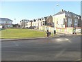
Newly constructed housing in The Drive
The pedestrians are waiting to cross Old Dover Road.
Image: © John Baker
Taken: 2 Dec 2012
0.02 miles
2
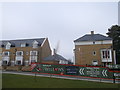
The Willows, Canterbury
This new housing estate constructed by Bellways is part of a re-development project at the St Lawrence Cricket Ground, helping the Kent Cricket Club through some recent financial troubles.
Image: © David Anstiss
Taken: 17 Feb 2013
0.02 miles
3
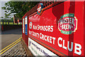
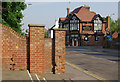
Kent County Cricket Club
This bright red sign at the junction of The Drive and Old Dover Road leaves nobody in any doubt as to the identity of Kent County Cricket Club's main sponsor.
Image: © Stephen McKay
Taken: 24 May 2008
0.03 miles
4
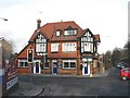
The aptly named Bat and Ball pub
Aptly named as it is immediately outside the Kent County cricket ground on the corner of St Lawrence Road and Old Dover Road.
Image: © Nick Smith
Taken: 28 Dec 2007
0.04 miles
5
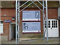
Information boards on the back of the Underwood and Knott stand, Canterbury
Alan Knott and Derek Underwood were among the greatest Kent and England players, whose First Class Cricket careers spanned the late 1960s to the mid 1980s. The stand named for them can be seen at Image
Image: © Ruth Sharville
Taken: 12 Jun 2022
0.04 miles
6
Old Dover Road, Canterbury
Taken from the steps leading into Kent County Cricket Ground, with the Bat & Ball pub at the junction with St Lawrence Road in the background.
Image: © Stephen McKay
Taken: 24 May 2008
0.04 miles
7
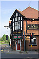
The Bat & Ball, Canterbury
Pub named for its proximity to Kent County Cricket Ground on the corner of Old Dover Road and St Lawrence Road.
Image: © Stephen McKay
Taken: 24 May 2008
0.05 miles
8
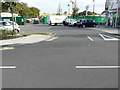
Looking southeast across The Drive
To where ongoing building work is being carried out. Planning permission has been granted by Canterbury City Council under application number CA//15/00870 for the “erection of 60 retirement living apartments with associated facilities, improvements to the cricket ground including landscaping, re-organisation of the supermarket car park and formation of new vehicular access (resubmission)”. The location of the development is Kent County Cricket Club, St Lawrence Ground. The area, where the cars are parked, is the supermarket’s carpark; the entrance to the supermarket is to the right of the dark-blue car.
Image: © John Baker
Taken: 18 Sep 2016
0.05 miles
9
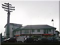
Sainsbury's Local, Canterbury
This new small supermarket has been built by Bellway as part of a re-development project (to raise funds for the ailing cricket club) on a part of the St.Lawrence Cricket ground.
The new spotlight is also part of the re-development, but it is causing problems for nearby householders.
Image: © David Anstiss
Taken: 17 Feb 2013
0.05 miles
10
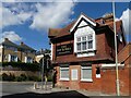
The "Bat and Ball" pub, seen from St Lawrence Road, Canterbury
The pub is close to the Kent County Cricket ground. It is on the junction of St Lawrence Road and Old Dover Road.
Image: © Ruth Sharville
Taken: 13 Jun 2022
0.05 miles