IMAGES TAKEN NEAR TO
Delf Street, SANDWICH, CT13 9HD
Introduction
This page details the photographs taken nearby to Delf Street, CT13 9HD by members of the Geograph project.
The Geograph project started in 2005 with the aim of publishing, organising and preserving representative images for every square kilometre of Great Britain, Ireland and the Isle of Man.

There are currently over 7.5m images from over14,400 individuals and you can help contribute to the project by visiting https://www.geograph.org.uk
Image Map (Loading...)


Getting Data...Please wait
Leaflet Map data © OpenStreetMap
Images are licensed for reuse under creativecommons.org/licenses/by-sa/2.0
Notes
- Clicking on the map will re-center to the selected point.
- The higher the marker number, the further away the image location is from the centre of the postcode.
Image Listing (736 Images Found)
Images are licensed for reuse under creativecommons.org/licenses/by-sa/2.0
Image
Details
Distance
3
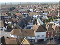
View from the top of St Peter's Church tower
The Church of St Peter is very much at the centre of Sandwich. The present church dates from the late 13th and early 14th centuries, when Sandwich was at the height of its prosperity. The central tower fell in 1661 and destroyed the south aisle which was never re-built. The replacement tower is a 17th-century addition, and was built by Flemish protestant refugees in the style of their homeland churches.
Every day at 8pm, the curfew bell rings out, signalling that the townspeople should cover their fires to make them safe for the night. This was once known as the 'pigbell’, as it also informed people they could release their animals into the street.
The church is Grade I Listed and is under the care of the Churches Conservation Trust. See http://www.visitchurches.org.uk/Ourchurches/Completelistofchurches/St-Peters-Church-Sandwich-Kent/ for more information.
The church is surrounded by attractive buildings as seen here, helped by the fact that Sandwich is the most complete medieval town in England. The impression is of a French or Dutch town because of its Flemish history. This view looks north-west towards Sandwich Windmill, right of centre in the distance.
Image: © Marathon
Taken: 28 Mar 2017
0.02 miles
4
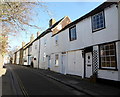
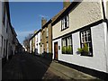
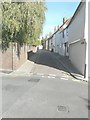
Bowling Street, Sandwich
Viewed from Delft Street.
Image: © pam fray
Taken: 25 Feb 2019
0.03 miles
5
Sanctuary Cottage, Vicarage Lane
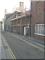
Scaffolding had been erected on its frontage, so that the existing roof tiles could be replaced with brand new tiles and it appeared that the chimney had been rebuilt.
Image: © John Baker
Taken: 19 Oct 2014
0.03 miles
6
Sanctuary Cottage, Vicarage Lane
Compared with Image, this shows how the house looked with the scaffolding removed and the building work completed.
Image: © John Baker
Taken: 23 Aug 2015
0.03 miles
8
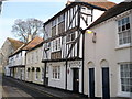
Bowling Street, Sandwich
Sandwich is the most complete medieval town in England. The impression is of a French or Dutch town because of the Flemish protestant refugees who came over in the 16th and 17th centuries. It has an intricate street pattern. This is Bowling Street, close to the junction with Delf Street.
Image: © Marathon
Taken: 28 Mar 2017
0.03 miles
9
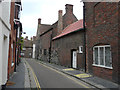
Bowling Street
Seen from its junction with Delf Street.
Image: © John Baker
Taken: 30 Oct 2013
0.03 miles
10
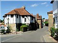
The Old Drum, Church Street St. Mary
One of the buildings to earn a "Historic Buildings of Kent" plaque. Circa 1450.
Image: © pam fray
Taken: 25 Feb 2008
0.03 miles