IMAGES TAKEN NEAR TO
Artillery Way, SANDWICH, CT13 9FL
Introduction
This page details the photographs taken nearby to Artillery Way, CT13 9FL by members of the Geograph project.
The Geograph project started in 2005 with the aim of publishing, organising and preserving representative images for every square kilometre of Great Britain, Ireland and the Isle of Man.

There are currently over 7.5m images from over14,400 individuals and you can help contribute to the project by visiting https://www.geograph.org.uk
Image Map
Images are licensed for reuse under creativecommons.org/licenses/by-sa/2.0
Notes
- Clicking on the map will re-center to the selected point.
- The higher the marker number, the further away the image location is from the centre of the postcode.
Image Listing (41 Images Found)
Images are licensed for reuse under creativecommons.org/licenses/by-sa/2.0
Image
Details
Distance
1
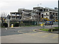
Building 180 gone and grassed over!
The Pfizer research labs at Sandwich, the building remaining is building 380 which was attached to Bld 180, all that remains of which is this grassed area, see Image and Image Pfizer is due to withdraw fully from Sandwich in 2012 but the site recently won an Enterprise Zone status which may help save some of it. See http://www.bbc.co.uk/news/uk-england-kent-14545748
Image: © Nick Smith
Taken: 4 Sep 2011
0.04 miles
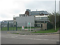
2
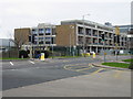
Entrance Gate into Pfizer's
As seen from Ramsgate Road.
This is one of the many gates into the highly secure Pfizer's pharmaceutical research company in Sandwich.
Note; the far sign on the right reads 'Cameras Prohibited'
But not from outside!
Image: © David Anstiss
Taken: 10 Apr 2011
0.04 miles
3
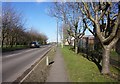
Ramsgate Road, near Sandwich
Running through the Sandwich Discovery Park.
Image: © Chris Whippet
Taken: 2 Aug 2015
0.05 miles
4
And the walls came tumbling down!
The old laboratories at Pfizer, the pharmaceutical research company, are being demolished. The windows have been removed, the building gutted and then the walls are being carefully knocked down. This is the north end of building 180.
Image: © Nick Smith
Taken: 13 Mar 2008
0.06 miles
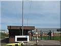
6
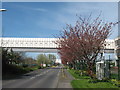
Pedestrian Bridge over Ramsgate Road
Ramsgate Road leads from Sandwich towards the A256 towards Ramsgate.
The bridge carries workers from two buildings in Pfizer's pharmaceutical research company in Sandwich.
The gate on the right is one of the gates into the large site.
Image: © David Anstiss
Taken: 10 Apr 2011
0.06 miles
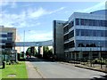
7
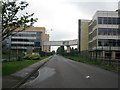
The Ramsgate Road passing through the Pfizer site
Pfizer is due to withdraw fully from Sandwich in 2012 but the site recently won an Enterprise Zone status which may help save some of it. See http://www.bbc.co.uk/news/uk-england-kent-14556823
Image: © Nick Smith
Taken: 4 Sep 2011
0.07 miles
8
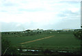
Pfizer Research site from Richborough Castle
Compare with Image to see the scale of development over the years. This shows the Pfizer research site before any development of the land to the west of the Sandwich to Ramsgate road. On the larger view it is possible to make out the Viking Garage which was to the west of the road until its demolition in the early or mid 1980's.
Image: © Nick Smith
Taken: Unknown
0.07 miles
9
End of an era
Demolition of the old research labs at Pfizer Ltd, Building 180 (where I started work) is being pulled down.
Image: © Nick Smith
Taken: 22 Feb 2008
0.08 miles