IMAGES TAKEN NEAR TO
Upper Strand Street, SANDWICH, CT13 9EE
Introduction
This page details the photographs taken nearby to Upper Strand Street, CT13 9EE by members of the Geograph project.
The Geograph project started in 2005 with the aim of publishing, organising and preserving representative images for every square kilometre of Great Britain, Ireland and the Isle of Man.

There are currently over 7.5m images from over14,400 individuals and you can help contribute to the project by visiting https://www.geograph.org.uk
Image Map
Images are licensed for reuse under creativecommons.org/licenses/by-sa/2.0
Notes
- Clicking on the map will re-center to the selected point.
- The higher the marker number, the further away the image location is from the centre of the postcode.
Image Listing (976 Images Found)
Images are licensed for reuse under creativecommons.org/licenses/by-sa/2.0
Image
Details
Distance
1
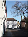
Fishergate, Sandwich
Once part of the defensive town wall and the route whereby fish were landed into this formerly important Cinque Port.
Image: © Dr Duncan Pepper
Taken: 6 Jul 2006
0.00 miles
2
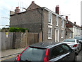
Repairs to Hazelbank, Upper Strand Street
Scaffolding has been erected at the back and along the west side of the house.
Image: © John Baker
Taken: 23 Aug 2015
0.01 miles
3
Hazelbank, Upper Strand Street
Last seen when Image were being carried out.
Image: © John Baker
Taken: 2 Oct 2016
0.01 miles
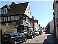
4
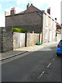
Fisher Street, looking towards Upper Strand Street
Image: © pam fray
Taken: 25 Feb 2008
0.02 miles
5

Christmas wreath in Upper Strand Street
I have to assume that the fox's head in Upper Strand Street in Sandwich was not real.
Image: © Marathon
Taken: 8 Dec 2022
0.02 miles
6
![Sandwich buildings [5]](https://s0.geograph.org.uk/geophotos/07/06/20/7062056_3805f68d_120x120.jpg)
Sandwich buildings [5]
This former warehouse was converted into flats in the mid 1980s. Built in the mid 19th century of yellow brick with red brick arches. Listed, grade II, with details at: https://historicengland.org.uk/listing/the-list/list-entry/1069600
Sandwich is a historic town in Kent, situated on the River Stour, 11½ miles east of Canterbury and 10½ miles north of Dover. Once a major port, one of the Cinque Ports, the town is now 2 miles inland due to the silting up of the Wantsum Channel. The town has a great many medieval buildings and was once home to a great many Flemish settlers. In Sandwich Bay are two world-class golf courses.
Image: © Michael Dibb
Taken: 7 Sep 2021
0.03 miles
8
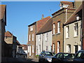
Houses on High Street
At the north end of the High Street a mix of grade II listed two and three storey brick housing.
Image: © Oast House Archive
Taken: 27 Jan 2012
0.03 miles
9
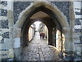
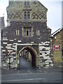
Looking through Fisher Gate to Quay Lane
Fisher Gate is the only one of the town gates of Sandwich to survive. Like much of the town's defences, it dates from around 1384. Beyond is Quay Lane.
Image: © Marathon
Taken: 12 Jan 2014
0.03 miles
10
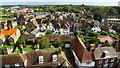
View from tower of St Peter's Church, Sandwich - rooftops towards High Street
Image: © Colin Park
Taken: 25 Sep 2019
0.03 miles