IMAGES TAKEN NEAR TO
Woodnesborough, SANDWICH, CT13 0PN
Introduction
This page details the photographs taken nearby to CT13 0PN by members of the Geograph project.
The Geograph project started in 2005 with the aim of publishing, organising and preserving representative images for every square kilometre of Great Britain, Ireland and the Isle of Man.

There are currently over 7.5m images from over14,400 individuals and you can help contribute to the project by visiting https://www.geograph.org.uk
Image Map
Images are licensed for reuse under creativecommons.org/licenses/by-sa/2.0
Notes
- Clicking on the map will re-center to the selected point.
- The higher the marker number, the further away the image location is from the centre of the postcode.
Image Listing (35 Images Found)
Images are licensed for reuse under creativecommons.org/licenses/by-sa/2.0
Image
Details
Distance

2
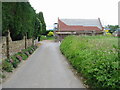
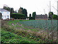
Farm building conversion on Coombe Lane
The houses in the background are on New Street on the outskirts of Ash, (and thanks to the lady who allowed me to park behind this conversion, as there are very few places to stop along this narrow country lane).
Image: © Nick Smith
Taken: 27 Jun 2008
0.07 miles
4
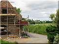
Some renovation work to property on Coombe Lane
Image: © Nick Smith
Taken: 27 Jun 2008
0.08 miles
10
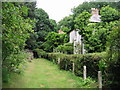
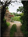
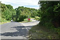
View along footpath from Fleming Road to Coombe Lane
The footpath is well maintained in front of Ringlton Gate, the house on the right.
Image: © Nick Smith
Taken: 27 Jun 2008
0.12 miles