IMAGES TAKEN NEAR TO
Thornton Lane, SANDWICH, CT13 0EU
Introduction
This page details the photographs taken nearby to Thornton Lane, CT13 0EU by members of the Geograph project.
The Geograph project started in 2005 with the aim of publishing, organising and preserving representative images for every square kilometre of Great Britain, Ireland and the Isle of Man.

There are currently over 7.5m images from over14,400 individuals and you can help contribute to the project by visiting https://www.geograph.org.uk
Image Map
Images are licensed for reuse under creativecommons.org/licenses/by-sa/2.0
Notes
- Clicking on the map will re-center to the selected point.
- The higher the marker number, the further away the image location is from the centre of the postcode.
Image Listing (41 Images Found)
Images are licensed for reuse under creativecommons.org/licenses/by-sa/2.0
Image
Details
Distance
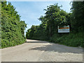
1
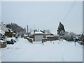
Road junction on Heronden Road
Gore Lane from Eastry divides here. Heronden Road heads right (and down) towards Heronden and Heronden Farms. Thornton Lane leads left to Thornton Farm.
Image: © David Anstiss
Taken: 19 Dec 2010
0.06 miles
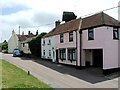
2
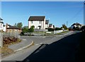
The new housing of Heronden View
This small development of residential housing was built just above the site of Eastry South railway station which was on the route of the dismantled East Kent Light Railway.
Image: © John Baker
Taken: 12 Oct 2009
0.09 miles
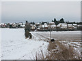
3
Approaching Eastry from the WSW
Along Heronden Road.
Image: © John Baker
Taken: 24 Dec 2017
0.10 miles
4
Houses at Heronden View, Eastry, from byway
The byway follows the field boundary and hedgeline and joins the road at the junctions of Heronden Road, Mill Lane and Gore Lane.
Image: © Nick Smith
Taken: 7 Jan 2010
0.11 miles
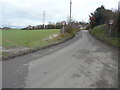
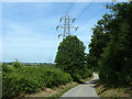
5

Fields and Pylon
From Thornton Road.
Image: © Oast House Archive
Taken: 18 Jul 2010
0.12 miles
6
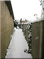
Footpath along the back of gardens near Mill Lane
Difficult to find exactly on the map but the path is signposted and emerges via some steps onto Heronden Road.
Image: © Nick Smith
Taken: 2 Dec 2010
0.12 miles
7
Entrance to commercial premises, Eastry
Ovenden Plant Hire, possibly others. The northern part of the site was originally a small hospital for infectious diseases about which I can find little information.
Image: © Robin Webster
Taken: 12 Jun 2014
0.13 miles
10
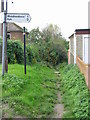
Start of the byway at the end of Mill Lane
Image: © Nick Smith
Taken: 3 Nov 2007
0.13 miles