IMAGES TAKEN NEAR TO
Boystown Place, SANDWICH, CT13 0DS
Introduction
This page details the photographs taken nearby to Boystown Place, CT13 0DS by members of the Geograph project.
The Geograph project started in 2005 with the aim of publishing, organising and preserving representative images for every square kilometre of Great Britain, Ireland and the Isle of Man.

There are currently over 7.5m images from over14,400 individuals and you can help contribute to the project by visiting https://www.geograph.org.uk
Image Map
Images are licensed for reuse under creativecommons.org/licenses/by-sa/2.0
Notes
- Clicking on the map will re-center to the selected point.
- The higher the marker number, the further away the image location is from the centre of the postcode.
Image Listing (201 Images Found)
Images are licensed for reuse under creativecommons.org/licenses/by-sa/2.0
Image
Details
Distance
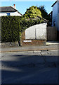
2
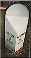
Old Milepost by the former A256, Sandwich Road, Eastry parish
Cast iron post by the UC road (was A256), in parish of EASTRY (DOVER District), Sandwich Road, opposite No. 2, Rookery Cottages, North of Boystown Place, in pavement against brick boundary wall, on East side of road. Sandwich metal post, erected by the Dover, Waldershare to Sandwich turnpike trust in the 19th century.
Inscription reads:-
: DOVER / 9 / MILES : : SANDWICH / 2½ / MILES :
Kent HER.
HER Number: TR 35 NW 827 https://www.heritagegateway.org.uk/Gateway/Results_Single.aspx?uid=MKE78214&resourceID=1005
Milestone Society National ID: KE_DOSW09.
Image: © C Woodward
Taken: 7 Mar 2008
0.07 miles
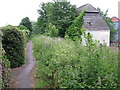
4
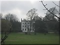
Walton House, Eastry
Grade II Listed building on Sandwich Road.
As seen from a footpath heading around the estate grounds.
See http://www.britishlistedbuildings.co.uk/en-178192-walton-house-and-coachhouse-adjoining-ea for more details about the building.
Image: © David Anstiss
Taken: 13 Feb 2011
0.08 miles
5
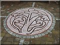
Mosaic of the trefoil flower, the centre piece of the new Parade
The trefoil flower, perhaps a symbol of the Blessed Virgin Mary to whom the church in Eastry is dedicated - or symbolic of Christ; is copied from one of the medieval frescoes in the church. http://www.eastrybenefice.co.uk/medallions.asp It has become the (un)official logo for the village
Image: © Nick Smith
Taken: 5 Jul 2008
0.08 miles
6
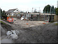
Rebuilding of 2, St Mary?s Close
Compared with Image, the demolition seems to have been completed. Planning permission has been granted by Dover District Council under application number DOV/15/00729 for the “erection of a single storey side extension, garage and roof extension incorporating a rear dormer, roof-lights and balcony (existing garden room to be demolished)”.
Image: © John Baker
Taken: 2 Dec 2015
0.08 miles
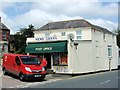
7
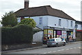
The Village Shop
Grade II listed. https://www.britishlistedbuildings.co.uk/101070183-the-general-stores-eastry
Image: © N Chadwick
Taken: 15 Feb 2018
0.09 miles
9
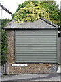
Small building, High Street
This was a Image in February 2019. The addition of the painted boards has greatly improved its appearance.
Image: © John Baker
Taken: 15 Oct 2019
0.09 miles