IMAGES TAKEN NEAR TO
Woodnesborough Road, SANDWICH, CT13 0AA
Introduction
This page details the photographs taken nearby to Woodnesborough Road, CT13 0AA by members of the Geograph project.
The Geograph project started in 2005 with the aim of publishing, organising and preserving representative images for every square kilometre of Great Britain, Ireland and the Isle of Man.

There are currently over 7.5m images from over14,400 individuals and you can help contribute to the project by visiting https://www.geograph.org.uk
Image Map
Images are licensed for reuse under creativecommons.org/licenses/by-sa/2.0
Notes
- Clicking on the map will re-center to the selected point.
- The higher the marker number, the further away the image location is from the centre of the postcode.
Image Listing (210 Images Found)
Images are licensed for reuse under creativecommons.org/licenses/by-sa/2.0
Image
Details
Distance
1
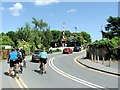
Level Crossing, Woodnesborough Road, Sandwich
Image: © Chris Whippet
Taken: 7 Jun 2015
0.02 miles
2
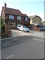
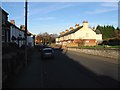
Glenourie, Woodnesborough Road
This is the nearer of the two houses shown in Image; the other is hidden from view.
Image: © John Baker
Taken: 2 Oct 2016
0.02 miles
3
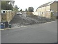
Land rear of 19-37 Woodnesborough Road
Planning permission has been granted by Dover District Council under application number DOV/13/00309 for the “erection of two detached dwellings and creation of a vehicular access”. Although not marked on the map as such, the addresses along this road are classified as being part of Woodnesborough Road by the council.
Image: © John Baker
Taken: 19 Nov 2013
0.03 miles
4
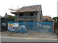
Erection of two houses
They are being built on Image Planning permission has been granted by Dover District Council under application number DOV/13/00309 for the “erection of two detached dwellings and creation of a vehicular access. Upon completion, the nearer house was named Image
Image: © John Baker
Taken: 23 Aug 2015
0.03 miles

6
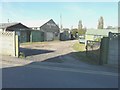
Derelict buildings, Woodnesborough Road
Although there is no road name on the map, Sandwich Leisure Park http://www.sandwich-leisurepark.co.uk/ includes Woodnesborough Road in its address. The building with the rectangular name-board was the premises of F T Wood Ltd.
Image: © John Baker
Taken: 30 Oct 2013
0.04 miles
7

Houses on Sandwich Road from Boatman's Hill cemetery
Image: © Nick Smith
Taken: 8 Feb 2008
0.04 miles
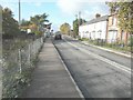
8
Level crossing, Woodnesborough Road
The terrace of white-painted houses are known as Hawthorn Cottages. A car is waiting at the crossing as the barriers were down.
Image: © John Baker
Taken: 19 Nov 2013
0.05 miles
10

Boatmans Hill Cemetery
Seen across Woodnesborough Road, the cemetery chapel bears the date 1855.
Image: © John Baker
Taken: 30 Oct 2013
0.06 miles