IMAGES TAKEN NEAR TO
Stour Street, CANTERBURY, CT1 2NZ
Introduction
This page details the photographs taken nearby to Stour Street, CT1 2NZ by members of the Geograph project.
The Geograph project started in 2005 with the aim of publishing, organising and preserving representative images for every square kilometre of Great Britain, Ireland and the Isle of Man.

There are currently over 7.5m images from over14,400 individuals and you can help contribute to the project by visiting https://www.geograph.org.uk
Image Map
Images are licensed for reuse under creativecommons.org/licenses/by-sa/2.0
Notes
- Clicking on the map will re-center to the selected point.
- The higher the marker number, the further away the image location is from the centre of the postcode.
Image Listing (2182 Images Found)
Images are licensed for reuse under creativecommons.org/licenses/by-sa/2.0
Image
Details
Distance
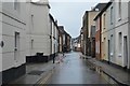
2
Looking northeast along Stour Street
The projecting building, encased in scaffolding and blue safety netting, is the former Highway Services building on the corner of Beer Cart Lane.
Image: © John Baker
Taken: 4 Feb 2015
0.01 miles
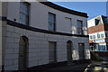
4
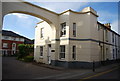
![Canterbury houses [208]](https://s0.geograph.org.uk/geophotos/07/10/48/7104804_41647195_120x120.jpg)
Canterbury houses [208]
Number 26 Stour Street was built in the late 18th or early 19th century. Constructed of painted brick under an old tile roof. Now used as offices. Listed, grade II, with details at: https://historicengland.org.uk/listing/the-list/list-entry/1259907
Canterbury is a small historic city on the River Stour in Kent, some 54 miles southeast of London. Occupied since prehistoric times, it became an important Roman city. In 672, the see of Canterbury gained authority over the entire English Church. After the murder of Archbishop Thomas Becket at the cathedral in 1170, pilgrims from all parts of Christendom came to visit his shrine until the Dissolution. Today, Canterbury is a popular tourist destination and one of the most-visited cities in the United Kingdom. The city has a substantial student population, with four university campuses.
Image: © Michael Dibb
Taken: 11 Sep 2021
0.01 miles
6
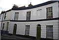
![Canterbury houses [215]](https://s1.geograph.org.uk/geophotos/07/10/56/7105601_cbc31989_120x120.jpg)
Canterbury houses [215]
Number 68 is an early 19th century house in buff brick. Number 68A is the single storey extension on the left with a carriage entrance. Listed, grade II, with details at: https://historicengland.org.uk/listing/the-list/list-entry/1242653
Canterbury is a small historic city on the River Stour in Kent, some 54 miles southeast of London. Occupied since prehistoric times, it became an important Roman city. In 672, the see of Canterbury gained authority over the entire English Church. After the murder of Archbishop Thomas Becket at the cathedral in 1170, pilgrims from all parts of Christendom came to visit his shrine until the Dissolution. Today, Canterbury is a popular tourist destination and one of the most-visited cities in the United Kingdom. The city has a substantial student population, with four university campuses.
Image: © Michael Dibb
Taken: 11 Sep 2021
0.01 miles

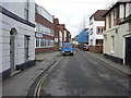
9
Georgian House, Stour St
Grade II listed. http://www.britishlistedbuildings.co.uk/en-443438-30-canterbury
Image: © N Chadwick
Taken: 14 May 2011
0.02 miles
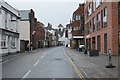
10

Looking east-northeast along Stour Street
Compared with Image, what was projecting over the street must have been scaffolding and blue safety netting, for the new building appears to be in line with the next house. Part of it houses the firm of Bang & Olufsen.
Image: © John Baker
Taken: 22 Nov 2015
0.02 miles