IMAGES TAKEN NEAR TO
Pound Lane, CANTERBURY, CT1 2NG
Introduction
This page details the photographs taken nearby to Pound Lane, CT1 2NG by members of the Geograph project.
The Geograph project started in 2005 with the aim of publishing, organising and preserving representative images for every square kilometre of Great Britain, Ireland and the Isle of Man.

There are currently over 7.5m images from over14,400 individuals and you can help contribute to the project by visiting https://www.geograph.org.uk
Image Map
Images are licensed for reuse under creativecommons.org/licenses/by-sa/2.0
Notes
- Clicking on the map will re-center to the selected point.
- The higher the marker number, the further away the image location is from the centre of the postcode.
Image Listing (1861 Images Found)
Images are licensed for reuse under creativecommons.org/licenses/by-sa/2.0
Image
Details
Distance
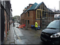
1

Building site, Pound Lane
Compared with Image, the ongoing construction of the houses continues. Planning permission has been granted by Canterbury City Council under application number CA//14/00604 for the “demolition of existing car showroom/car preparation buildings, alterations and extension to an existing showroom with flat above to allow conversion to 2 dwellings and residential redevelopment comprising 10 houses”. The car showrooms/car preparation buildings relate to those that belonged to the firm of Barretts.
Image: © John Baker
Taken: 10 Jul 2016
0.01 miles
2
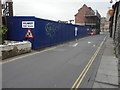
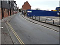
Looking south-southwest along Pound Lane
The blue hoarding hides a building site. Planning permission has been granted by Canterbury City Council under application number CA//14/00604 for the “demolition of existing car showroom/car preparation buildings, alterations and extension to an existing showroom with flat above to allow conversion to 2 dwellings and residential redevelopment comprising 10 houses”. The car showrooms/car preparation buildings relate to those that belonged to the firm of Barretts. The existing showroom, referred to in the application, now has scaffolding on its frontage. This is another view of Image taken on 22 November 2015.
Image: © John Baker
Taken: 27 Dec 2015
0.01 miles
3
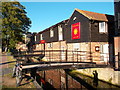
![Canterbury buildings [54]](https://s1.geograph.org.uk/geophotos/07/08/86/7088689_4f03a0f2_120x120.jpg)
Canterbury buildings [54]
Set alongside the River Stour, this former 18th century wool store, numbers 4 and 5 Pound Lane, was restored with a grant from English Heritage. It showcases the extensive use of reclaimed building material from the 14th century city wall. The left part is constructed of flint and brick to the ground floor with weatherboarding above, under a hipped old tile roof. The right part is of flint and robbed mediaeval masonry with stone dressings. This is a view of the front to Pound Lane, the view of the front to North Lane is at Image Now in use as a restaurant. Listed, grade II, with details at: https://historicengland.org.uk/listing/the-list/list-entry/1241655
Canterbury is a small historic city on the River Stour in Kent, some 54 miles southeast of London. Occupied since prehistoric times, it became an important Roman city. In 672, the see of Canterbury gained authority over the entire English Church. After the murder of Archbishop Thomas Becket at the cathedral in 1170, pilgrims from all parts of Christendom came to visit his shrine until the Dissolution. Today, Canterbury is a popular tourist destination and one of the most-visited cities in the United Kingdom. The city has a substantial student population, with four university campuses.
Image: © Michael Dibb
Taken: 6 Sep 2021
0.01 miles
4
Ongoing construction of houses, Pound Lane
Compared with Image, much construction has taken place during the past four months. Planning permission has been granted by Canterbury City Council under application number CA//14/00604 for the “demolition of existing car showroom/car preparation buildings, alterations and extension to an existing showroom with flat above to allow conversion to 2 dwellings and residential redevelopment comprising 10 houses”. The car showrooms/car preparation buildings relate to those that belonged to the firm of Barretts. The road past the building site had been closed to vehicular traffic.
Image: © John Baker
Taken: 9 Nov 2016
0.01 miles
6
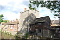
Part of the town walls
A tower converted to a house. Grade II listed. http://www.britishlistedbuildings.co.uk/en-440824-6-canterbury
Image: © N Chadwick
Taken: 14 May 2011
0.01 miles
7
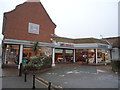
Cafe du Soleil
Living up to its name here beside the Great Stour.
The plaque on the bridge reads Guys Bridge 1994
Image: © Des Blenkinsopp
Taken: 20 Aug 2011
0.01 miles
9
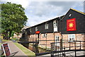
![Canterbury buildings [55]](https://s3.geograph.org.uk/geophotos/07/08/97/7089759_191b3be9_120x120.jpg)
Canterbury buildings [55]
Set alongside the River Stour, this former 18th century wool store, numbers 4 and 5 Pound Lane, was restored with a grant from English Heritage. It showcases the extensive use of reclaimed building material from the 14th century city wall. The left part is constructed of flint and brick to the ground floor with weatherboarding above, under a hipped old tile roof. The right part is of flint and robbed mediaeval masonry with stone dressings. This is the view of the North Lane front, there is a view of the Pound Lane front at Image Now in use as a restaurant. Listed, grade II, with details at: https://historicengland.org.uk/listing/the-list/list-entry/1241655
Canterbury is a small historic city on the River Stour in Kent, some 54 miles southeast of London. Occupied since prehistoric times, it became an important Roman city. In 672, the see of Canterbury gained authority over the entire English Church. After the murder of Archbishop Thomas Becket at the cathedral in 1170, pilgrims from all parts of Christendom came to visit his shrine until the Dissolution. Today, Canterbury is a popular tourist destination and one of the most-visited cities in the United Kingdom. The city has a substantial student population, with four university campuses.
Image: © Michael Dibb
Taken: 6 Sep 2021
0.01 miles
10
Building site, Pound Lane
Planning permission has been granted by Canterbury City Council under application number CA//14/00604 for the “demolition of existing car showroom/car preparation buildings, alterations and extension to an existing showroom with flat above to allow conversion to 2 dwellings and residential redevelopment comprising 10 houses”. The car showrooms/car preparation buildings relate to those that belonged to the firm of Barretts.
This is another view of the Image taken on 27 December 2015.
Image: © John Baker
Taken: 22 Nov 2015
0.01 miles