Canterbury buildings [54]
Introduction
The photograph on this page of Canterbury buildings [54] by Michael Dibb as part of the Geograph project.
The Geograph project started in 2005 with the aim of publishing, organising and preserving representative images for every square kilometre of Great Britain, Ireland and the Isle of Man.

There are currently over 7.5m images from over 14,400 individuals and you can help contribute to the project by visiting https://www.geograph.org.uk
Canterbury buildings [54]
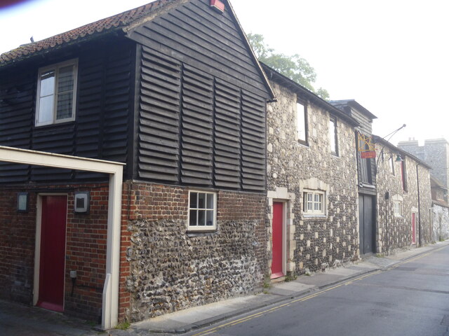
Image: © Michael Dibb Taken: 6 Sep 2021
Set alongside the River Stour, this former 18th century wool store, numbers 4 and 5 Pound Lane, was restored with a grant from English Heritage. It showcases the extensive use of reclaimed building material from the 14th century city wall. The left part is constructed of flint and brick to the ground floor with weatherboarding above, under a hipped old tile roof. The right part is of flint and robbed mediaeval masonry with stone dressings. This is a view of the front to Pound Lane, the view of the front to North Lane is at Image Now in use as a restaurant. Listed, grade II, with details at: https://historicengland.org.uk/listing/the-list/list-entry/1241655 Canterbury is a small historic city on the River Stour in Kent, some 54 miles southeast of London. Occupied since prehistoric times, it became an important Roman city. In 672, the see of Canterbury gained authority over the entire English Church. After the murder of Archbishop Thomas Becket at the cathedral in 1170, pilgrims from all parts of Christendom came to visit his shrine until the Dissolution. Today, Canterbury is a popular tourist destination and one of the most-visited cities in the United Kingdom. The city has a substantial student population, with four university campuses.
Images are licensed for reuse under creativecommons.org/licenses/by-sa/2.0
Image Location
Latitude
51.282113
Longitude
1.076852