IMAGES TAKEN NEAR TO
High Street, CANTERBURY, CT1 2JH
Introduction
This page details the photographs taken nearby to High Street, CT1 2JH by members of the Geograph project.
The Geograph project started in 2005 with the aim of publishing, organising and preserving representative images for every square kilometre of Great Britain, Ireland and the Isle of Man.

There are currently over 7.5m images from over14,400 individuals and you can help contribute to the project by visiting https://www.geograph.org.uk
Image Map
Images are licensed for reuse under creativecommons.org/licenses/by-sa/2.0
Notes
- Clicking on the map will re-center to the selected point.
- The higher the marker number, the further away the image location is from the centre of the postcode.
Image Listing (2575 Images Found)
Images are licensed for reuse under creativecommons.org/licenses/by-sa/2.0
Image
Details
Distance
1
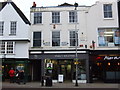
![Canterbury buildings [238]](https://s1.geograph.org.uk/geophotos/07/11/03/7110377_90e435d1_120x120.jpg)
Canterbury buildings [238]
The rendered brick front of number 8 High Street is part of a terrace built in 1866 after a fire. Behind the front is a late 14th century, timber framed, double jettied house with a cellar. The rear elevation was altered in the 18th century, the ground floor being underbuilt in brick, the upper floors rendered. On the second storey are two original medieval windows with holes for window bars and sliding shutter grooves. Listed, grade II, with details at: https://historicengland.org.uk/listing/the-list/list-entry/1258219
Canterbury is a small historic city on the River Stour in Kent, some 54 miles southeast of London. Occupied since prehistoric times, it became an important Roman city. In 672, the see of Canterbury gained authority over the entire English Church. After the murder of Archbishop Thomas Becket at the cathedral in 1170, pilgrims from all parts of Christendom came to visit his shrine until the Dissolution. Today, Canterbury is a popular tourist destination and one of the most-visited cities in the United Kingdom. The city has a substantial student population, with four university campuses.
Image: © Michael Dibb
Taken: 11 Sep 2021
0.01 miles
2
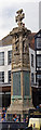
Canterbury War Memorial
The central pillar records those who died in World War I, while plaques at the base commemorate those who died in World War II.
Image: © The Carlisle Kid
Taken: 18 Jun 2013
0.01 miles
4
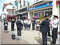
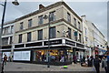
Hymns in the High Street
The Salvation Army in full swing. Looking along High Street towards the West Gate, Guildhall Street can be seen on the right just beyond Debenhams.
Image: © pam fray
Taken: 3 May 2009
0.01 miles
5
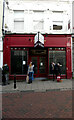
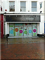
Jigsaw, 7, High Street
Before the shop was permanently closed, it was part of a stylish fashion chain offering contemporary clothing for men, women and children, plus homewares.
Image: © John Baker
Taken: 6 Dec 2020
0.01 miles
6
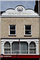
The Sun Fire Office
This building in the High Street was once the home of an early insurance company.
Image: © Peter Jeffery
Taken: 7 May 2016
0.01 miles
7
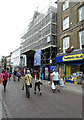
High Street, Canterbury
The building with its frontage encased in scaffolding. is the Beaney House of Art and Knowledge, which is the central museum, library and art gallery. It is housed in a grade II listed building. Until it closed for refurbishment in 2009, it was known as the Beaney Institute or the Royal Museum and Art Gallery. It reopened under its new name in September 2012. The building, museum and art gallery are owned and managed by Canterbury City Council; Kent County Council is the library authority. These authorities work in partnership with stakeholders and funders https://en.wikipedia.org/wiki/Beaney_House_of_Art_and_Knowledge
Image: © John Baker
Taken: 4 Aug 2019
0.01 miles
8
Disused entrance, High Street
This was one of the entrances to the department store Debenhams, which closed permanently in 2020.
Image: © John Baker
Taken: 25 Oct 2020
0.01 miles