IMAGES TAKEN NEAR TO
City Wall Avenue, CANTERBURY, CT1 2FZ
Introduction
This page details the photographs taken nearby to City Wall Avenue, CT1 2FZ by members of the Geograph project.
The Geograph project started in 2005 with the aim of publishing, organising and preserving representative images for every square kilometre of Great Britain, Ireland and the Isle of Man.

There are currently over 7.5m images from over14,400 individuals and you can help contribute to the project by visiting https://www.geograph.org.uk
Image Map
Images are licensed for reuse under creativecommons.org/licenses/by-sa/2.0
Notes
- Clicking on the map will re-center to the selected point.
- The higher the marker number, the further away the image location is from the centre of the postcode.
Image Listing (729 Images Found)
Images are licensed for reuse under creativecommons.org/licenses/by-sa/2.0
Image
Details
Distance
1
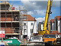
Construction works at The Old Tannery
New homes under construction by Bellway Homes.
Image: © Oast House Archive
Taken: 20 Apr 2012
0.02 miles
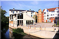
2

Modern housing development by the Great Stour
By the Great Stour to the east of Rheims Way, on the site of the old tannery.
Image: © pam fray
Taken: 2 Mar 2023
0.03 miles
3

New homes at The Old Tannery
Recently completed homes constructed by Bellway Homes.
Image: © Oast House Archive
Taken: 20 Apr 2012
0.04 miles
4
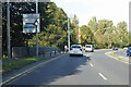
A2050 Rheims Way, Canterbury
A more ring-like bit of a Canterbury ring road system. A bridge over one strand of the Great Stour is just ahead. Some maps label this stretch as the A290.
Image: © Robin Webster
Taken: 13 Oct 2018
0.04 miles
5
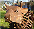
"Bull" by Stephen Portchmouth, Westgate Parks, Canterbury
The sculpture, of which this is a detail, provides an interpretation linked to the past use of the site as a 'slub bank' for the disposal of waste from St Mildred's Tannery. Whilst creating the wildflower meadow at Tannery Field, part of the old Tannery Railway track was unearthed. This sculpture interprets this past history.
Image: © pam fray
Taken: 19 Jan 2018
0.04 miles
6
Great Stour past The Old Tannery
Image: © Oast House Archive
Taken: 20 Apr 2012
0.04 miles
7
New Apartments by the Great Stour
A whole new community of residential blocks has been created in this part of town.
Image: © Des Blenkinsopp
Taken: 28 Aug 2011
0.04 miles
8
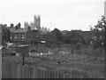
Allotments, Canterbury, 1965
The allotments are no longer there - they have been built over with housing around the line of Old Watling Street, and the terraces on St Peter's Grove on the left now join onto the new estate. As with the allotments, I think wherever I was standing when I took this has also changed fundamentally - I suspect it is now Rheims Way. However, the cathedral is still there.
Image: © Derek Harper
Taken: Unknown
0.04 miles
9
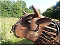
Bull sculpture, Tannery Field, Canterbury
Designed to reflect the industrial and agricultural heritage of the landscape, the Canterbury Bull was commissioned by Westgate Parks officer Anna Bell and paid for with Heritage Lottery Funding. It is made from old railway track by Steven Portchmouth. Tannery Field is the green space between Rheims Way and the river, opposite the Old Tannery housing development. Long before Rheims Way was built the area was part of the city’s largest tannery, hence the name.
Image: © pam fray
Taken: 31 Jul 2016
0.04 miles
10

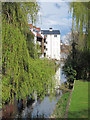
Great Stour seen from the Stour Valley Walk
The Great Stour splits into two branches at Bingley's Island just west of here on the other side of Rheims Way (A290) and passes through Canterbury before meeting up again near Vauxhall Lakes Nature Reserve. This view is from a footbridge which carries the Stour Valley Walk over the southern branch of the Great Stour. The flats on the left are in Tannery Way South.
Image: © Marathon
Taken: 14 Dec 2013
0.05 miles