IMAGES TAKEN NEAR TO
Tannery Way North, CANTERBURY, CT1 2FH
Introduction
This page details the photographs taken nearby to Tannery Way North, CT1 2FH by members of the Geograph project.
The Geograph project started in 2005 with the aim of publishing, organising and preserving representative images for every square kilometre of Great Britain, Ireland and the Isle of Man.

There are currently over 7.5m images from over14,400 individuals and you can help contribute to the project by visiting https://www.geograph.org.uk
Image Map
Images are licensed for reuse under creativecommons.org/licenses/by-sa/2.0
Notes
- Clicking on the map will re-center to the selected point.
- The higher the marker number, the further away the image location is from the centre of the postcode.
Image Listing (1442 Images Found)
Images are licensed for reuse under creativecommons.org/licenses/by-sa/2.0
Image
Details
Distance
1
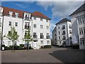
Apartments on Old Watling Street
Image: © Oast House Archive
Taken: 20 Apr 2012
0.03 miles
2
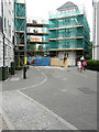
Old Watling Street
It appears that the apartments on both sides of the road, which are part of the St Mildred’s Tannery development, may be undergoing external renovation.
Image: © John Baker
Taken: 4 Aug 2019
0.03 miles
3
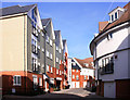
New Housing, Canterbury
A whole new neighbourhood has been created to the west of the city centre between the Great Stour and the by-pass.
A lot of design variation and a non linear street plan has been used to avoid a "new estate" look.
Image: © Des Blenkinsopp
Taken: 28 Aug 2011
0.04 miles
4

New homes at The Old Tannery
Recently completed homes constructed by Bellway Homes.
Image: © Oast House Archive
Taken: 20 Apr 2012
0.04 miles
5
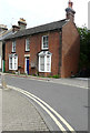
St Peters Villa, 59, St Peter?s Grove
The house had an air of neglect about it, as the hanging baskets either side of the front door contained dead plants and there were further dead plants in pots on the pavement below.
Image: © John Baker
Taken: 4 Aug 2019
0.05 miles
6
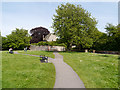
Canterbury, Greyfriars Garden
Greyfriars Garden, beside the Great Stour, at the heart of the busy city of Canterbury, is the oldest Franciscan site in the UK, where the first Franciscans to come to this country arrived in 1224. Greyfriars Chapel, which may once have been the friary guest house, is all that is left of the 13th century friary.
Image: © David Dixon
Taken: 16 May 2013
0.06 miles
7
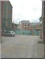
Clearwater Mews, off Stour Street
This is a development of 6 houses, 3 duplexes and 1 penthouse being built by TG Designer Homes http://tgdesignerhomes.com/city/ In my photograph of Image, the entrance to the mews is the gap between St Mildred’s Tannery and the houses to its right.
Image: © John Baker
Taken: 24 Aug 2014
0.06 miles
8
Clearwater Mews, off Stour Street
Compared with Image, photographed in August 2014, the building in the foreground now almost obscures that behind it.
Image: © John Baker
Taken: 4 Feb 2015
0.06 miles
9
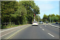
A2050 Rheims Way, Canterbury
A more ring-like bit of a Canterbury ring road system. Some maps label this stretch as the A290.
Image: © Robin Webster
Taken: 13 Oct 2018
0.07 miles
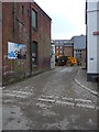
10
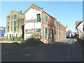
All that remains of St Mildred's Tannery, Stour Street
The rest has been demolished to make way for the development known as The Old Tannery which extends to Rheims Way. Planning permission has been granted by Canterbury City Council under application number CA//04/00012 for the “demolition of buildings in connection with redevelopment to provide 444 houses and flats, 283 off-street car parking spaces, 64 bed hotel, 4 retail units (A1), 1 wine bar/restaurant (A3), 3 live/work units, 2 pedestrian bridges, public park and riverside walk”. The site has been occupied by the tannery since the 18th century.
Image: © John Baker
Taken: 2 Dec 2012
0.07 miles