IMAGES TAKEN NEAR TO
Church Lane St. Radigunds, CANTERBURY, CT1 2AG
Introduction
This page details the photographs taken nearby to Church Lane St. Radigunds, CT1 2AG by members of the Geograph project.
The Geograph project started in 2005 with the aim of publishing, organising and preserving representative images for every square kilometre of Great Britain, Ireland and the Isle of Man.

There are currently over 7.5m images from over14,400 individuals and you can help contribute to the project by visiting https://www.geograph.org.uk
Image Map
Images are licensed for reuse under creativecommons.org/licenses/by-sa/2.0
Notes
- Clicking on the map will re-center to the selected point.
- The higher the marker number, the further away the image location is from the centre of the postcode.
Image Listing (1727 Images Found)
Images are licensed for reuse under creativecommons.org/licenses/by-sa/2.0
Image
Details
Distance
2
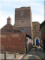
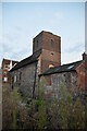
Tower of St Mary Northgate, Canterbury
St Mary Northgate has not been in use as a church since 1912, although the name of this alleyway - Church Lane - as well as the architecture testify to its former use. It is now used by the Kings School across the road as a theatre.
According to a plaque on the building, its origins lie in an Anglo-Saxon chapel above the city gate (hence the name) which was demolished c.1800, but most of the present building is 19th century.
Image: © Stephen Craven
Taken: 17 Jun 2010
0.00 miles
3
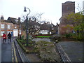
St Radigund's Garden and St Mary's Church
Remains of the Roman wall form the rear boundary of St Radigund's Garden, which is seen ahead in this photograph. Here the Roman wall stands to a height of about twenty feet and is one of the most complete standing walls in Britain. In the 12th century the wall was heightened to form the north wall of St Mary's Church, the tower of which can be seen on the right. St Radigund's Garden was created by Canterbury City Council between 1978 and 1979.
Image: © Marathon
Taken: 14 Dec 2013
0.00 miles
5
![Canterbury features [48]](https://s0.geograph.org.uk/geophotos/07/09/98/7099844_e1e567ec_120x120.jpg)
Canterbury features [48]
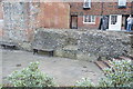
The wall at the rear of this garden in St Radigund's Street is part of the Roman walls around Canterbury (Durovernum Cantiacorum). Built between 270 and 290 AD the walls were generally repaired in the Middle Ages, but the original Roman construction survives in many places. Here the Roman wall stands to a height of about 20 feet. It was heightened in the 12th century to form the north wall of St Mary's church and is one of the most complete standing Roman walls in Britain. See also Image and Image A Scheduled Ancient Monument with details at: https://historicengland.org.uk/listing/the-list/list-entry/1003554
Canterbury is a small historic city on the River Stour in Kent, some 54 miles southeast of London. Occupied since prehistoric times, it became an important Roman city. In 672, the see of Canterbury gained authority over the entire English Church. After the murder of Archbishop Thomas Becket at the cathedral in 1170, pilgrims from all parts of Christendom came to visit his shrine until the Dissolution. Today, Canterbury is a popular tourist destination and one of the most-visited cities in the United Kingdom. The city has a substantial student population, with four university campuses.
Image: © Michael Dibb
Taken: 6 Sep 2021
0.00 miles
7
![Canterbury features [47]](https://s2.geograph.org.uk/geophotos/07/09/98/7099842_f13358d6_120x120.jpg)
Canterbury features [47]
The wall at the rear of this garden in St Radigund's Street is part of the Roman walls around Canterbury (Durovernum Cantiacorum). Built between 270 and 290 AD the walls were generally repaired in the Middle Ages, but the original Roman construction survives in many places. Here the Roman wall stands to a height of about 20 feet. It was heightened in the 12th century to form the north wall of St Mary's church and is one of the most complete standing Roman walls in Britain. See also Image and Image A Scheduled Ancient Monument with details at: https://historicengland.org.uk/listing/the-list/list-entry/1003554
Canterbury is a small historic city on the River Stour in Kent, some 54 miles southeast of London. Occupied since prehistoric times, it became an important Roman city. In 672, the see of Canterbury gained authority over the entire English Church. After the murder of Archbishop Thomas Becket at the cathedral in 1170, pilgrims from all parts of Christendom came to visit his shrine until the Dissolution. Today, Canterbury is a popular tourist destination and one of the most-visited cities in the United Kingdom. The city has a substantial student population, with four university campuses.
Image: © Michael Dibb
Taken: 6 Sep 2021
0.01 miles
8
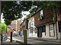
The Parrot on Church Lane
A gastropub on a Canterbury back-street.
Image: © Stephen Craven
Taken: 17 Jun 2010
0.01 miles
9
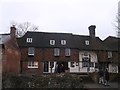
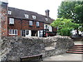
The Parrot Pub, Canterbury
This is also St Radigund's Hall (a Grade II listed former Wealden Hall) on Church Lane.
In 1937 it was nearly demolished, then saved and converted into a Girl's Club, then a restaurant and then pub (now incorporated into the Shepherd Neame group).
In the foreground is part of the ruins of the city walls of Canterbury.
See also Image
See http://www.britishlistedbuildings.co.uk/en-170574-st-radigund-hall-kent for more details about the listed hall.
Image: © David Anstiss
Taken: 23 Mar 2013
0.01 miles
10

The Parrot Pub Sign, Canterbury
On Image on Church Lane.
Image: © David Anstiss
Taken: 23 Mar 2013
0.01 miles